White Bay (New South Wales)
White Bay is a bay on Sydney Harbour with a surrounding locality near the suburbs of Balmain and Rozelle in the Inner West of Sydney, New South Wales, Australia.
History
White Bay is named after John White, the naval surgeon aboard the First Fleet to Australia in 1788.[1] Since the nineteenth century the bay has been used for water-based transport and industrial activities. In conjunction with adjacent Glebe Island it has been a multipurpose port, owned and controlled by the Government of New South Wales since 1901.[2][3]
White Bay was the first port in New South Wales to handle containerised shipping, from 1969. In the 1970s there were several companies operating container terminals, with rail transfer to larger holding yards at Chullora. Container handling moved out of White Bay in late 2004, relocating to Darling Harbour.[4]
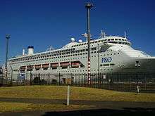
The White Bay Cruise Terminal opened in April 2013 replacing an earlier terminal elsewhere in Sydney Harbour. White Bay is also used for marine refuelling.[4]
White Bay also caters for break bulk cargo (timber, paper, motor vehicles and steel) and dry bulk cargoes (cement, sugar, gypsum, aggregates, etc.).
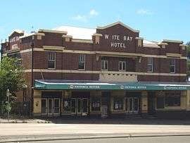
The White Bay Hotel [5] was a historic hotel on Victoria Road. It was first built in 1861, rebuilt in 1916, and refurbished in 1925 and 1933. It finally closed in 1992, "landlocked" by roads and with no local workers. Until 2004 it served only as a platform for billboards advertising to traffic on the Western Distributor, and on 5 September 2008 was destroyed by a suspicious[6] fire and immediately demolished. The NSW state government bought the site in June 2010.[7]
The rubble was removed on 29 October 2010 and the block levelled.
Landmarks
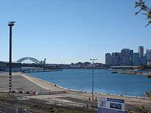
The derelict White Bay Power Station dominates the landscape. On the eastern side stands the magnificent Anzac Bridge, which was completed in 1996 and is the main arterial link between the inner west and Sydney city.[8] Below the bridge lies its predecessor, the Glebe Island Bridge,[8] which opened in 1903.
 White Bay Power Station
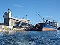 Glebe Island grain silos
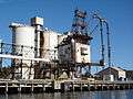 Balmain Coal Loader
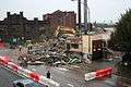 Hotel Demolition
 Beatrice Bush Bridge, bike and pedestrian access over Victoria Road
Notable residents
For 25 years from 1971 to just before her death in 1996, one of Sydney's true characters, Beatrice Olive ("Beattie") Bush, sold papers to passing motorists at the junction of The Crescent (City West Link) and Victoria Road.[9] Every morning in all weather, wearing Balmain Tigers socks and running shoes, Beatrice was part of the drive to work for thousands of motorists.[9]
The 1984 song The White Bay Paper Seller by Judy Small was written about Beatrice. The 1986 painting Beatrice the Paper-Seller of the White Bay Intersection by Susan Dorothea White shows Beatrice Bush running between the cars and trucks, selling newspapers in the rain. The 2004 documentary, The Paper Queen by Julie Nebauer documented her life.[10] In 2005 a new cycle bridge crossing Victoria Road at the intersection of The Crescent was named the Beatrice Bush Bridge in her honour.[8] Her newspaper trolley, hat, gloves and other clothing items are held in the Powerhouse Museum collection in Sydney.[9]
See also
References
- ↑ "White Bay". Geographical Names Register (GNR) of NSW. Geographical Names Board of New South Wales. Retrieved 12 October 2013.
- ↑ Sydney Ports; Glebe Island and White Bay Master Plan, Part A; 2000;
- ↑ Sydney Ports; Glebe Island and White Bay Master Plan, Part B; 2000;
- 1 2 "Tall Ships to Cruise Ships - White Bay History 1854 to Present" (PDF). Sydney Ports Corporation. 11 April 2013. Retrieved 6 January 2017.
- ↑ White Bay Hotel Heritage Report
- ↑ ABC News, 7pm, 6 September 2008
- ↑ State snaps up White Bay Hotel site (SMH)
- 1 2 3 Roads and Traffic Authority, NSW; ANZAC Bridge, ; Retrieved on 5 November 2006.
- 1 2 3 Powerhouse Museum; Statement of significance: Newspaper trolley owner by Beatrice Bush; ; Retrieved on 5 November 2006.
- ↑ Australian Film Commission; The Paper Queen; Film Database Entry; ; Retrieved on 5 November 2006.
External links
| Wikimedia Commons has media related to White Bay, New South Wales. |
- reference and article (cc-by-sa) at the Dictionary of Sydney
- Sydney Ports - Master Plans
- Local Images at InnerWest ImageBank
- Local History Collection, Leichhardt Council
- Disney held unsolicited discussions with the NSW Department of State and Regional Development about the redevelopment of White Bay
- Beer may flow once again at White Bay Hotel
- Last Drinks at Rozelle's Historic White Bay Hotel
- Susan Dorothea White's 1986 painting 'Beatrice the Paper-Seller of the White Bay Intersection'