Weymouth Landing/East Braintree station
WEYMOUTH LANDING/EAST BRAINTREE | |||||||||||||
|---|---|---|---|---|---|---|---|---|---|---|---|---|---|
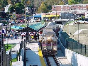 A ceremonial train at the station on October 30, 2007, one day before the Greenbush Line opened | |||||||||||||
| Location |
121 Commercial Street Weymouth, Massachusetts | ||||||||||||
| Coordinates | 42°13′14.88″N 70°58′1.52″W / 42.2208000°N 70.9670889°WCoordinates: 42°13′14.88″N 70°58′1.52″W / 42.2208000°N 70.9670889°W | ||||||||||||
| Owned by | Massachusetts Bay Transportation Authority | ||||||||||||
| Line(s) | |||||||||||||
| Platforms | 1 side platform | ||||||||||||
| Tracks | 1 | ||||||||||||
| Construction | |||||||||||||
| Parking |
290 spaces ($4.00 fee) 13 accessible spaces | ||||||||||||
| Disabled access | Yes | ||||||||||||
| Other information | |||||||||||||
| Fare zone | 2 | ||||||||||||
| History | |||||||||||||
| Opened | October 31, 2007[1] | ||||||||||||
| Closed | June 30, 1959 | ||||||||||||
| Previous names | Weymouth | ||||||||||||
| Traffic | |||||||||||||
| Passengers (2013) | 375 (weekday inbound average)[2] | ||||||||||||
| Services | |||||||||||||
| |||||||||||||
| |||||||||||||
Weymouth Landing/East Braintree (signed as East Braintree/Weymouth Landing) is an MBTA Commuter Rail station on the border of Braintree and Weymouth, Massachusetts. It serves the Greenbush Line. It is located in Weymouth Landing, and consists of a single side platform serving the line's one track. The station is fully handicapped accessible.
History
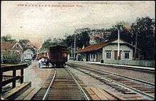
The New Haven Railroad abandoned its remaining Old Colony Division lines on June 30, 1959, after the completion of the Southeast Expressway.[1] The Weymouth station had been located just west of Commercial Street.[3]
The MBTA reopened the Greenbush Line on October 31, 2007, with Weymouth station located between Commercial Street and Quincy Avenue.[1] Original plans called for a 450-foot (140 m) platform between the streets, but the MBTA ultimately decided to build a standard 800-foot (240 m) platform that extends under the streets at either end.
Bus connections
The station is also served by one MBTA Bus route:
- 225 Quincy Center - Weymouth Landing via Quincy Avenue & Shaw Street or Des Moines Road
References
- 1 2 3 Belcher, Jonathan (December 30, 2016). "Changes to Transit Service in the MBTA district 1964-2016" (PDF). NETransit.
- ↑ "Ridership and Service Statistics" (PDF) (14th ed.). Massachusetts Bay Transportation Authority. 2014.
- ↑ "Weymouth Landing". Atlas of Norfolk County. Comstock & Cline. 1876 – via Ward Maps.
External links
![]()