Westport station (Light RailLink)
Westport | |||||||||||
|---|---|---|---|---|---|---|---|---|---|---|---|
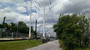 View of station from Kloman Street | |||||||||||
| Location |
2114 Kloman Street Baltimore, Maryland | ||||||||||
| Coordinates | 39°15′43.49″N 76°37′52.72″W / 39.2620806°N 76.6313111°WCoordinates: 39°15′43.49″N 76°37′52.72″W / 39.2620806°N 76.6313111°W | ||||||||||
| Owned by | Maryland Transit Administration | ||||||||||
| Line(s) | |||||||||||
| Platforms | 2 side platforms | ||||||||||
| Tracks | 2 | ||||||||||
| Connections |
| ||||||||||
| Services | |||||||||||
| |||||||||||
Westport station is a Baltimore Light Rail station in Baltimore, Maryland. It is located north of Smith Cove on the west side of the Patapsco River in Baltimore's the Westport neighborhood. It currently has no free public parking but has connections to MTA Maryland buses 27 and 51.[1]
Station layout
| G | |
| Side platform, doors will open on the right | |
| Southbound | ← Light Rail toward BWI Airport or Cromwell (Cherry Hill) |
| Northbound | Light Rail toward Timonium or Hunt Valley (Hamburg Street) → |
| Side platform, doors will open on the right | |
| Street level | Exit/entrance |
References
External links
This article is issued from
Wikipedia.
The text is licensed under Creative Commons - Attribution - Sharealike.
Additional terms may apply for the media files.