Westpoort
| Westpoort (Amsterdam) | |
|---|---|
| Borough of Amsterdam | |
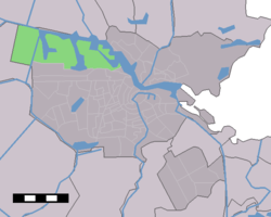 The location of Westpoort in Amsterdam | |
| Country |
|
| Province | North Holland |
| COROP | Amsterdam |
| Area | |
| • Total | 35.47 km2 (13.70 sq mi) |
| • Land | 26 km2 (10 sq mi) |
| Population | |
| • Total | 370 |
| • Density | 10/km2 (27/sq mi) |
| Time zone | UTC+1 (CET) |
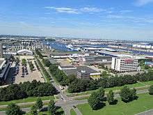
Westpoort (Western Gateway or Western Port) is a borough (stadsdeel) of Amsterdam, Netherlands. The borough covers the Port of Amsterdam, the main harbour and industrial area of the city, and is located in the north-western part of Amsterdam. It is divided in the industrial areas of Teleport, Sloterdijk areas I, II and II, De Heining and the harbour area (Havengebied). It is home to over 1,500 companies, with an estimated 45,000 people employed in the area.[1]
The borough has very few permanent inhabitants. Unlike the other Amsterdam boroughs, Westpoort does not have its own district committee. Instead, it is governed directly by the central municipal council, as a port and industrial park rather than a neighborhood.
The northern border of the area is formed by the North Sea Canal. The district borders the boroughs of West and Nieuw-West and the municipality of Haarlemmerliede en Spaarnwoude (including the town of Halfweg).
References
- ↑ Amsterdam.nl - Westpoort (Dutch only)
External links
Coordinates: 52°24′21″N 4°49′16″E / 52.40583°N 4.82111°E
 | ||
| ||
| Centrum | ||
|---|---|---|
| Nieuw-West | ||
| Noord | ||
| Oost |
| |
| West | ||
| Zuid | ||
| Zuidoost |
| |
| Westpoort | ||
Former boroughs: De Baarsjes - Geuzenveld-Slotermeer - Oost-Watergraafsmeer - Oud-West - Oud-Zuid - Slotervaart - Westerpark - Zeeburg - Zuideramstel | ||