West Lomond
| West Lomond | |
|---|---|
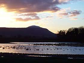 West Lomond from the Howe of Fife at sunset | |
| Highest point | |
| Elevation | 522 m (1,713 ft) |
| Prominence | 405 m (1,329 ft) |
| Listing | Marilyn |
| Geography | |
| Parent range | Ben Cleuch |
| OS grid | NO197066 |
| Topo map | OS Landranger 58 |
West Lomond is the highest point in the county of Fife, Scotland and the highest peak in the Lomond Hills. Its volcanic dolerite cone rises above an escarpment of carboniferous sandstone and limestone layers. The conspicuous peaks of West Lomond, and its neighbour East Lomond, are visible for many miles around, which explains their name, the 'Lomond' or 'Beacon' hills. On the summit are the remains of an Iron Age Hill fort.
West Lomond is usually climbed from Craigmead car park on the Falkland-Leslie road, as this sits at a height of almost 300 metres. Another route of ascent leaves from the Bunnet Stane and climbs diagonally up the steep north slopes of the escarpment to a gap in the cliffs, above which one gains the plateau a short distance from the summit cone. This route is steeper and begins at a much lower altitude than the Craigmead car park.
Geodesy
Until 1891 West Lomond was the meridian of the 6 inch and 1:2500 Ordnance Survey maps of Kinross and Fife. After that the maps of Kinross and Fife were drawn according to the meridian of The Buck in Aberdeenshire.[1]