Wessex Basin
The Wessex Basin is a petroliferous geological area located along the southern coast of England and stretches into the English Channel.[2] The on land area the basin covers comes close to approximately 20000 km2 and the area that encompasses the English Channel is also roughly about the same size.[3] The basin was first characterized as an extensional basin that was created during the Permian and early Cretaceous Era in response to the tectonic plate movement of the African plate with the Eurasian plate.[4] In the late the cretaceous, the basin was then classified as an inversion basin coinciding again with the same tectonic activity.[4] The basin is usually compartmentalized into 4 main sub-basins including the Winterborne-Kingston Trough, Channel Basin, Weald Basin, and Vale of Pewsey Basin.[4] The area is also rich in hydrocarbons with several offshore wells in the area.[5] With the large interest in the hydrocarbon exploration of the area, data became more readily available and therefore came a better understanding of the type of inversion tectonics that characterize this basin.[4]
Tectonic mechanisms
The basin was first created in response to a divergent boundary between the African and Eurasian plates.[4] Lithospheric thinning and crustal extension led to the subsidence and consequently the creation of asymmetrical graben.[6] These events happened in pulses starting in the Permian and concluding in the early Cretaceous period.[6] By mid Cretaceous the active crustal extension ceased and the region underwent a period of unfaulted subsidence in part due to the thermal relaxation effects from the earlier lithospheric action.[4] Inversion began starting in the late Cretaceous and carried on through Tertiary times coinciding with the Alpine orogeny happening at the now convergent boundary of the African and Eurasian plates.[4]
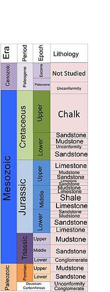
Basement structure and stratigraphy
Starting at the basement of the structure, the area of interest overlies Variscan externides consisting of Devonian and Carboniferous sediments in imbricated thrust sheets.[4] The Hercynian basement was rather thin in origin with the thrust emplacement in a north-northwest trend developed most likely with a strike-slip fault.[4] After the conclusion of the initial Hercynian deformation, normal reactivation of these same faults occurred along with differential subsidence beginning in the late Carboniferous as a direct result from the northwest/southeast trending wrench movements.[4] The sands created within this period lie in an unconformed manner atop the Devonian and Carboniferous basement.[4] The asymmetrical grabens are found within these sands and through the use of dating techniques mark the point in history of basin initiation during the late Carboniferous.[4] Following this stage the basin underwent a period of erosion removing approximately 10 km of sediment from the area with the following Permian sediment deposition being dictated by the former Hercynian structure.[4] This semi-arid, desert sedimentation occurred on the western portion of the basin with the clasts eventually thinning as they progress towards the east side of the basin.[4] Triassic sediments sit atop of the Permian layer again in an unconformed manner with the makeup being mainly sand and silts.[4] Like the former stage, the Triassic sediments were first concentrated on the west side of the basin but also overwhelmingly appeared in the southwest as a direct result from marine transgression.[4] The Jurassic period followed with the same marine sedimentation , but by the end of the period, sea-level began to shallow leaving behind shallow marine sediments.[4] The Cretaceous period marks a major transition as the area became unstable with the basement faults reactivating and additional deposition of 1000m of brackish non-marine/freshwater sediments along with major uplift of the basin margins.[4] The later Cretaceous consisted of deposition almost entirely of chalk with a basin wide unconformity delineating the period between the Tertiary and Late Cretaceous.[4] These sediments are important as they represent the marker bed that the inversion of the basin begins.[5]
Basin inversion
It's important to note that one of the most obvious signs of the beginning of basin inversion is that the timing of the Wessex Basin inversion correlates directly with other adjacent inversion basins.[4] The basin’s inversion mechanism can be traced back to the movements of the alpine orogeny that resulted in a series of monoclines along the boundary faults and the uplift of pre-tertiary sediments.[4] Inversion can happen along reactivated fault lines and in this case the faults involved are the Mesozoic tensional growth faults.[4] The reverse movements of the tensional faults in response reactivated the basement faults but this time as thrust faults.[4] Former structural highs underwent inversions to become areas where large amounts of sediments began being deposited, while also slowly deepening to the basement faults.[4] The transpression of the whole are is the most probable cause for the subsidence of the former basin high points.[4] The amount of deepening of a former high structure correlates directly with the amount of over thrusting.[4] Simply, the faults have to completely reverse the previous movements and then some in order to see a reversal of structure changes.
In addition, there are several sediment depositional environments that also help catalog when and where initial basin inversion was happening. Basin erosion during the late Cretaceous and early Tertiary is one of the first indicators along with a regional change in the chalk composition to non-marine fluvial sediments.[4] Major chalk fissures also became infilled with Paleocene sediments.[4] There are east-west trending styolites specifically in the Pubreck chalk formation that date the onset of the compression, the start of the inversion.[4] Additionally, Eocene paleosols created during the late Cretaceous south of the Purbeck- Isle of Wright fault line is a direct contrast of the marine sediments of the same age to the north.[4]
Presently the basin is described with a series of east-west trending monoclonal and antiforms that lie above the underlying Mesozoic growth faults.[4] The Purbreck-Isle of Wright fault is one of the areas where inversion of the basin is distinctly seen with pre and post inversion structures.[4]
Hydrocarbons
Hydrocarbon exploration led to immense seismic profiling in the areas of South Dorset, Hampshire, and the Isle of Wright.[5] The petroleum geology is primarily confided in the Mesozoic strata being first drilled in 1937.[7] The Kimmeridge oilfield is an offshore field that was first discovered in the 1950s is the largest in the area and is still in production to this day.[7] Wytch Farm is the major onshore field that entered production during the 1970s.[7] This basin stems from three major source rocks known as the Blue Lias formation with Liassic clays, the Oxford Clay formation, and the Kimmeridge clay formation.[7]
See also
References
- ↑ Worden, R.H; Benshatwan, M.S; Potts, G.J; Elgarmadi, S.M (2016). "Basin Scale Fluid Movement Patterns Revealed by Veins Wessex Basin U.K". Geofluids. 16: 149–174 – via Science Direct.
- ↑ Stoneley, R (January 1982). "The Structural Development of the Wessex Basin". Journal of the Geological Society. 139: 543–554 – via Science Direct.
- ↑ Chadwick, R.A (January 1993). "Aspects of Basin Inversion in Southern Britain". Journal of the Geological Society. 150: 311–322 – via Science Direct.
- 1 2 3 4 5 6 7 8 9 10 11 12 13 14 15 16 17 18 19 20 21 22 23 24 25 26 27 28 29 30 31 32 Lake, Stuart; Karner, Garry D. (1987). "The Structure and evolution of the Wessex Basin, Southern England: An Example of Inversion Tectonics". Tectonophysics. 137: 347–378 – via Science Direct.
- 1 2 3 Underhill, J.R; Paterson, S. (January 1998). "Genesis of Tectonic Inversion Structures: Seismic Evidence for the Development of Key Structures along the Purbeck-Isle of Wight Disturbance". Journal of the Geological Society. 155: 975–992 – via Science DIrect.
- 1 2 Chadwick, R.A (1986). "Extension Tectonics in the Wessex Basin, Southern England". Journal of the Geological Society. 143: 465–488.
- 1 2 3 4 Zanella, A (2015). "Natural Hydraulic Fractures in the Wessex Basin, SW England: Widespread Distribution, Composition and History". Marine and Petroleum Geology. 68: 438–448 – via Science Direct.