Wellington Island
| Native name: Isla Wellington | |
|---|---|
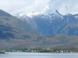 Puerto Edén on Wellington Island in the foreground | |
 Wellington | |
| Geography | |
| Location | Pacific Ocean |
| Coordinates | 49°20′S 74°40′W / 49.333°S 74.667°WCoordinates: 49°20′S 74°40′W / 49.333°S 74.667°W |
| Area | 5,555.7 km2 (2,145.1 sq mi) |
| Coastline | 1,596.8 km (992.21 mi) |
| Highest elevation | 1,463 m (4,800 ft) |
| Highest point | Unnamed[1] |
| Administration | |
| Region | Magallanes |
| Province | Última Esperanza Province |
| Commune | Puerto Natales |
| Demographics | |
| Population | 340 (2017) |
| Ethnic groups | Alacaluf |
| Additional information | |
| NGA UFI=-901551 | |
Wellington Island is an island west of Southern Patagonian Ice Field, Chile. It has an area of 5,556 km² and most of the island forms part of Bernardo O'Higgins National Park. It is home to the last Kawésqar people, living in the village of Puerto Edén, the only inhabited place on the island.
See also
- Serrano Island, also named Little Wellington Island
References
This article is issued from
Wikipedia.
The text is licensed under Creative Commons - Attribution - Sharealike.
Additional terms may apply for the media files.