Well, North Yorkshire

Well is a small village and civil parish in the Hambleton district of North Yorkshire, England. It is about 4 miles south of Bedale, near Snape. The population taken at the 2011 Census was 230.[1]
The 'well' of Well is a spring which, along with several other springs, feeds the beck running through the village.
There is a small church called St. Michael's.
The village has an old school with a school house. Although the school has been out of use for a long time, the school house has only just been vacated. They are both owned by "The Neville Trust", a charity named after an influential family from the Tudor period. With this is also a small playing field comprising two swings and a small football pitch and, as this is rarely used by the children in the village, the trust is now planning to sell all assets.
The village still has four almshouses called St Michael's Cottages with their own chapel.
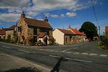
There is a family-run pub called The Milbank Arms which serves food and drink, as well as hosting darts and dominoes teams, and pub quizzes.
There is also a Methodist Chapel, which holds regular services, and a village institute, which is used for children's parties, coffee mornings and other events. Every August the village hosts a scarecrow trail in which many of the houses in the village create a scarecrow and give it a name; each house then has a number, and members of the community have to work out which name belongs to which scarecrow. The winner receives a cash prize. The competition usually runs from mid-August to early September.
The village also has a number of walks with views across the area; on a clear day, Roseberry Topping is visible.
References
- 1 2 UK Census (2011). "Local Area Report – Well Parish (1170216955)". Nomis. Office for National Statistics. Retrieved 4 July 2018.
External links
![]()
- Well Village Website Contains information on the village and history.