Weaverthorpe
| Weaverthorpe | |
|---|---|
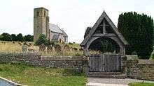
.jpg) Looking north over Weaverthorpe | |
 Weaverthorpe Weaverthorpe shown within North Yorkshire | |
| Population | 349 (2011 census)[1] |
| OS grid reference | SE965708 |
| District | |
| Shire county | |
| Region | |
| Country | England |
| Sovereign state | United Kingdom |
| Post town | MALTON |
| Postcode district | YO17 |
| Police | North Yorkshire |
| Fire | North Yorkshire |
| Ambulance | Yorkshire |
| EU Parliament | Yorkshire and the Humber |
| UK Parliament |
|
Weaverthorpe is a village and civil parish in the Ryedale district of North Yorkshire, England. It is 13 miles (21 km) south-west of Scarborough.[2]
History
Bronze Age settlements have been found at nearby Cowlam, which is 2.8 miles (4.5 km) to the south.[2] It was one of the leading burial sites in Yorkshire where the dead were interred in their chariots.[3]
There was a vill on the site in the period of Viking/Norse settlement when it was known as Wifertorp (11th century). The village's name is linked to a certain Vidhfari, anglicized in Wivar. In the Domesday Book there is a mention of Wiveretorp where it was classed as very small and had depreciated in value from 1066 to 1086.[4] Same male's name as in Wiverton (Nottingham) and in the Vierville (Wiarevilla 1158), Virville (Wivarevilla v. 1210) and Viertot of Normandy which appears to come from Old Scandinavian; which means that Weaverthorpe translates as the farm or settlement of the male name Vidhfari or Wivar.[5][6]
After the Norman conquest it was held by the Archbishop of York under Michael FitzHerbert. In the 12th century the church of St. Andrew was granted to Nostell Priory until 1268. Lucy, daughter of Piers FitzHerbert, married Sir William de Ros of Helmsley-in-Holderness [alias Hamlake) (died c. 1264) who acquired the manor of 'Wyverthorp'. In about 1271 the manor was acquired by William de Brewes, Baron Braose of Gower, on his marriage with Mary de Ros.[7]
Weaverthorpe was listed as being in the Wapentake of Buckrose which encompassed various villages in the East Riding of Yorkshire.[8] It is now in the Ryedale district of North Yorkshire.[9]
During the Second World War, MI6 secretly installed a new type of direction finding station in a field just south of the village, it consisted of an underground metal tank with an aerial protruding above rotated by the operator inside the tank. The station was used to find the locations of German secret service radio stations and their spies in Europe.[10]
Church of St Andrew
The tower is reputed to be a mix of late Saxon and Norman in construction. The chancel is separated from the nave by a Norman arch. The font is probably Norman. Above the south door of the nave is a sun-dial, with a part-illegible fragment of an inscription in Saxon characters, claimed as reading: " In honore Sancti andre - Herbert W.... Hoc Monasterium ". It has been claimed as a memorial to Herbert de Winchester (died 1120/1130) who built the church.[11] Herbert of Winchester was chamberlain to King Henry I. His son William FitzHerbert was granted by King John, the lands of "Launsborough, Collerthorpe, Wyderthorpe, Holperthorpe and the two Lottum". The unexplained reference to "ecclesiam de Clera[m]" in the charter of King Stephen relating to "Wiverthorpe", might refer to a chapel attached to a local manor house.
A Victorian benefactor of Weaverthorpe's St Andrew's church, was local landowner Sir Tatton Sykes. He paid for 18 rural churches to be built, repaired or rebuilt in the East and North Yorkshire areas, but mainly in the Wolds. St Andrew's church was restored by G E Street with "lavish furnishings and decorated roofs".[12] The Yorkshire Post described the church as boasting some impressive stained glass windows.[13] The church was listed as Grade I in October 1966.[11]
Geography
The village sits in the Gypsey Race valley where the waters flow alongside the main street in the village.[14] The waters of the Gypsey Race have carved a small valley out of the surrounding chalk. This has left small plateaus like the one that the Church of St Andrew is perched on as it overlooks the village.[15][16]
The village is served by unclassified roads and lies 3.1 miles (5 km) south of the A64 road at Sherburn.[2] There was a railway station on the York to Scarborough Line at Sherburn which was called Weaverthorpe.[17] It had been renamed from Sherburn to Wykeham and then renamed again to Weaverthorpe. This was to avoid confusion over place names (as there was a Wykeham station on the Forge Valley Line between Pickering and Seamer).[18]
References
- ↑ UK Census (2011). "Local Area Report – Weaverthorpe Parish (1170217309)". Nomis. Office for National Statistics. Retrieved 9 March 2018.
- 1 2 3 "101" (Map). Scarborough & Bridlington (C1 ed.). 1:50,000. Landranger. Ordnance Survey. 2016. ISBN 9780319261996.
- ↑ Roe, Derek Arthur (1970). "6: The Iron Age". Prehistory: an introduction (1 ed.). London: Palgrave MacMillan. p. 210. ISBN 9781349003600.
- ↑ Powell-Smith, Anna. "Weaverthorpe, Domesday Book". opendomesday.org. Retrieved 13 March 2017.
- ↑ Ekwall, Eilert (1960). The concise Oxford dictionary of English place-names (4 ed.). Oxford: Clarendon Press. p. 503. ISBN 0-19-869103-3.
- ↑ Smith, A.H. (1970). The place-names of the East Riding of Yorkshire and York (2 ed.). Cambridge: University Press. p. 122. ISBN 9780521049078.
- ↑ Magna Carta Ancestry: A Study in Colonial and Medieval Families By Douglas Richardson, Kimball G. Everingham Published 2005, Genealogical Publishing Com; p. 136
- ↑ "A description of the East Riding of Yorkshire, 1892: Part 3". www.genuki.org.uk. Retrieved 13 March 2017.
- ↑ "Ryedale". data.gov.uk. Office for National Statistics. Retrieved 13 March 2017.
- ↑ "MI6 in Weaverthorpe". Luttons and Weaverthorpe. 20 July 2015. Retrieved 13 March 2017.
- 1 2 Historic England. "Church of St Andrew (Grade I) (1175527)". National Heritage List for England. Retrieved 13 March 2017.
- ↑ "On the trail of Sir Tatton Sykes' churches". York Press. 27 April 2013. Retrieved 13 March 2017.
- ↑ "Crumbling churches find guardian angel". The Yorkshire Post. 5 May 2013. Retrieved 13 March 2017.
- ↑ "Weaverthorpe - The Villages of the Yorkshire Wolds - Driffield YO25". www.driffield.co.uk. Retrieved 13 March 2017.
- ↑ Fox-Strangways, Charles Edward (1906). "Introduction: Outline of geology as far as relates to water supply". The water supply, from underground sources, of the East Riding of Yorkshire, together with the neighbouring portions of the Vales of York and Pickering: with records of sinkings and borings. London: HMSO. p. 11. OCLC 876761985.
- ↑ Morris, Joseph E (1932). "I. Area, population and divisions". The east Riding of Yorkshire. London: Methuen & Co. p. 9. OCLC 752835245.
- ↑ Chapman, Stephen (2008). York to Scarborough, Whitby & Ryedale (1 ed.). Todmorden: Bellcode Books. p. 46. ISBN 9781871233193.
- ↑ "Sherburn Parish Plan 2009" (PDF). sherburnparishcouncil.org.uk. p. 7. Retrieved 13 March 2017.
(Note: Interesting that William FitzHerbert was granted such lands by a king whose reign did not begin until 1199; when William, archbishop and saint, had died back in 1154.)
Bibliography
Gazetteers e.g.: "Bulmer's History and Directory of East Yorkshire (1892)"
External links
![]()