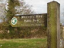
Weavers' Way
For the consumer cooperative in Philadelphia see Weavers Way Co-op
| Weavers' Way | |
|---|---|
 Weavers' Way | |
| Length | 61 mi (98 km) |
| Location | Norfolk |
| Trailheads |
Cromer 52°55′58″N 1°18′03″E / 52.9327°N 1.3008°E Great Yarmouth 52°36′23″N 1°44′12″E / 52.6063°N 1.7368°E |
| Use | Walking |
| Elevation | |
| Highest point | 250 feet (76 m) |
| Hiking details | |
| Season | All year round |
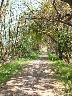
The Weavers' Way is 61-mile (98 km) long distance footpath in Norfolk, England.[1]
Route
The Weavers' Way is runs from Cromer to Great Yarmouth. It passes through Hanworth, Aylsham, North Walsham. Worstead, Stalham, Potter Heigham, Thurne and Halvergate before crossing the marshes around Berney Arms and skirting the northern edge of Breydon Water where it shares the same route as the Wherryman's Way.[2]
The name Weavers' Way comes from the cloth industry that was once a major industry in the area before the industrial revolution.
At Cromer, the Weavers' Way links with the North Norfolk Coastal Path, and at Great Yarmouth it joins the Angles Way. Combined with the Peddars Way the trails make a circuit around Norfolk.
References
- ↑ "About Weavers' Way and points of interest". Norfolk County Council.
- ↑ The Weavers' Way on the LDWA website
External links
- The Weavers' Way on the Norfolk County Council website.
Coordinates: 52°46′38″N 1°30′09″E / 52.7773°N 1.5026°E
| Wikimedia Commons has media related to Weavers' Way. |