Weaverland Bridge
| Weaverland Bridge | |
|---|---|
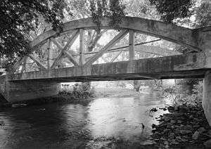 Weaverland Bridge in 2003. | |
| Coordinates | 40°8′16″N 76°3′34″W / 40.13778°N 76.05944°WCoordinates: 40°8′16″N 76°3′34″W / 40.13778°N 76.05944°W |
| Carries | Quarry Road (Township Route 894) |
| Crosses | Conestoga River |
| Locale | Terre Hill, Pennsylvania |
| Maintained by | East Earl Township |
| Characteristics | |
| Design | Bowstring arch truss |
| Material | Concrete |
| Total length | 58.8 feet (17.9 m) |
| Width | 19.8 feet (6.0 m) |
| Longest span | 58.8 feet (17.9 m) |
| No. of spans | 1 |
| History | |
| Designer | Frank H. Shaw |
| Constructed by | John T. Brubaker |
| Opened | 1916 |
Weaverland Bridge carries Quarry Road (Township Route 894) across the Conestoga River near Terre Hill, East Earl Township, Lancaster County, Pennsylvania, in the United States. The bridge is notable for its form, a concrete bowstring arch truss. Designer Frank H. Shaw was a consulting engineer to Lancaster County when the bridge was constructed in 1916. Weaverland Bridge was determined to be eligible for the National Register of Historic Places in 1993.[1]
See also
References
- ↑ Vidutis, Richard (August 2002). "Weaverland Bridge" (PDF). Historic American Engineering Record. Washington, D.C.: Library of Congress. p. 1. Retrieved March 3, 2018.
External links
- Historic American Engineering Record (HAER) No. PA-589, "Weaverland Bridge", 7 photos, 1 color transparency, 3 measured drawings, 29 data pages, 2 photo caption pages
- Frank Harold Shaw information at Structurae
- Weaverland Bridge at Structurae
This article is issued from
Wikipedia.
The text is licensed under Creative Commons - Attribution - Sharealike.
Additional terms may apply for the media files.