Watergate, Chester
| Watergate | |
|---|---|
 Watergate | |
| Coordinates | 53°11′22″N 2°53′51″W / 53.1894°N 2.8974°WCoordinates: 53°11′22″N 2°53′51″W / 53.1894°N 2.8974°W |
| Carries | City wall |
| Crosses | A458 |
| Locale | Chester, Cheshire |
| Heritage status | Grade I listed |
| Characteristics | |
| Design | Arch bridge |
| Material | Sandstone |
| History | |
| Designer | Joseph Turner |
| Opened | 1790 |
| Statistics | |
| Toll | None |
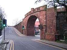
The Watergate is in Chester, Cheshire, England and spans the A548 road between Watergate Street and New Crane Street (grid reference SJ402662). It forms part of the city walls and carries a footpath over the road. It is recorded in the National Heritage List for England as a designated Grade I listed building.[1]
Watergate was built between 1788 and 1790 for Chester City Council and replaced a medieval gate. The architect was Joseph Turner. It is built in red sandstone ashlar and consists of a basket arch of short rusticated voussoirs. The parapet consists of stone balusters interspersed with panels. A drinking fountain, which is now dry, is fixed to the north abutment and is dated 1857.[1]
See also
References
- 1 2 Historic England, "The Watergate, Chester (1376468)", National Heritage List for England, retrieved 15 July 2012
External links
This article is issued from
Wikipedia.
The text is licensed under Creative Commons - Attribution - Sharealike.
Additional terms may apply for the media files.