Wat's Dyke
| Clawdd Wat | |
 Wat's Dyke near Northop, Wales. | |
| Location | England–Wales border |
|---|---|
| Type | Earthwork |
| Material | Earth |
| Length | Up to 40 mi (64 km) |
| Completion date | 8th century |
Coordinates: 52°59′12″N 3°1′43″W / 52.98667°N 3.02861°W
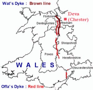
Wat's Dyke (Welsh: Clawdd Wat) is a 40-mile (64 km) earthwork running through the northern Welsh Marches from Basingwerk Abbey on the River Dee estuary, passing to the east of Oswestry and on to Maesbury in Shropshire, England. It runs generally parallel to Offa's Dyke, sometimes within a few yards but never more than three miles away. It now appears insignificant, sometimes a raised hedgerow and in other places is now no more than a cropmark, the ditch long since filled in and the bank ploughed away, but originally it was a considerable construction, considered to be more sophisticated than Offa's Dyke.[1]
Construction and siting
It consists of the usual bank and ditch of an ancient dyke, with the ditch on the western side, meaning that the dyke faces Wales and by implication can be seen as protecting the English lands to the east. The placement of the dyke in the terrain also shows that care was taken to provide clear views to the west and to use local features to the best defensive advantage.
Dating controversy
The dyke was previously thought to date to the early 8th century, constructed by Aethelbald king of Mercia who reigned from 716 to 757. Aethelbald's successor, Offa, built the dyke which carries his name at some point during his reign (757 to 796).
Excavations in the 1990s at Maes-y-Clawdd near Oswestry uncovered the remains of a small fire site together with eroded shards of Romano-British pottery and quantities of charcoal, which have been dated to between 411 and 561 AD (centered around 446 AD).[2] This evidence would seem to place the building of the dyke in the era of the post-Roman kingdom whose capital was at Wroxeter (just south of modern-day Shrewsbury) about 10 miles to the east.[1]
The dating of the fire site and hence the dyke has been disputed, and it has been suggested that owing to the difficulties inherent in radiocarbon dating, this single date cannot be trusted and also that the dyke could easily have been built on top of the fire site at a later date.[3]
Excavations in 2006 suggested a much later date of 792–852, and the earlier date is now thought to relate to a fire site which preceded the dyke. A likely context for construction is the 820s, when the Mercian king Coenwulf was fighting against a resurgent Welsh threat.[4]
Wat's Dyke Way
The approximate line of the earthwork is followed by the Wat's Dyke Way, a waymarked long-distance path running for 40 miles (64 km) from Llanymynech in Powys to Basingwerk Abbey on the River Dee near Holywell. It was opened in 2007.[5]
See also
- Scots' Dike, a 3½-mile linear earthwork constructed in 1552 to mark the division of the Debatable lands and thereby settle the exact boundary between the Kingdoms of Scotland and England.
References
- 1 2 Nurse, Keith (2001). "Wat's In A Name?". Retrieved 10 June 2018.
- ↑ Denison, Simon, ed. (November 1999). "Dyke redated". British Archaeology. 49. Archived from the original on 19 July 2012. Retrieved 10 June 2018.
- ↑ Matthews, Keith J. (c. 2000). "Dating Wat's Dyke". Retrieved 10 June 2018.
- ↑ "Wat's Dyke Dated: Was it Coenwulf's Dyke?". British Archaeology. 97. November–December 2007. Archived from the original on 19 April 2012. Retrieved 10 June 2018.
- ↑ "Wat's Dyke Way". Wat's Dyke Way Association. Retrieved 10 June 2018.
Further reading
- Blake, Steve and Scott, Lloyd (2003): The Keys to Avalon: The True Location of Arthur’s Kingdom Revealed. Revised Edition, published by Rider.
- Hannaford, H. R. (1998): "Archaeological Excavations on Wat’s Dyke at Maes-y-Clawdd," Archaeology Service, Shropshire County Council, report no. 132, December 1997.
- Worthington, Margaret (1997): '"Wat’s Dyke: An Archaeological and Historical Enigma," Bulletin John Rylands Library, Manchester, Vol 79, no. 3, 1997.
External links
| Wikimedia Commons has media related to Wat's Dyke. |
- www.geograph.co.uk - photos of Wat's Dyke today