Wankers Corner, Oregon
| Wankers Corner | |
|---|---|
| Unincorporated community | |
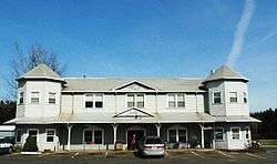 Wanker's Country Store | |
 Wankers Corner Location within the state of Oregon  Wankers Corner Wankers Corner (the US) | |
| Coordinates: 45°22′30″N 122°42′8″W / 45.37500°N 122.70222°WCoordinates: 45°22′30″N 122°42′8″W / 45.37500°N 122.70222°W | |
| Country | United States |
| State | Oregon |
| County | Clackamas |
| Time zone | UTC-8 (Pacific (PST)) |
| • Summer (DST) | UTC-7 (PDT) |
| ZIP code | 97062 |
| Area code(s) | 503 and 971 |
Wankers Corner is an unincorporated area centered at the intersection of Stafford Road and Borland Road in Clackamas County, Oregon, United States. Because this is not a recognized community, it has never had a post office, nor does it consistently appear on maps of Oregon (although the AAA map of Oregon shows it in an inset). The United States Geological Survey classifies Wankers Corner as a "locale":[1] "a place at which there is or was human activity".[2] It has frequently been noted on lists of unusual place names.[3]
References
- ↑ "Feature Query Results". United States Board on Geographic Names, United States Geological Survey. Retrieved 2010-09-21.
- ↑ "Feature Class Definitions". United States Board on Geographic Names, United States Geological Survey. Retrieved 2010-09-21.
- ↑ Parker, Quentin (2010). Welcome to Horneytown, North Carolina, Population: 15: An insider's guide to 201 of the world's weirdest and wildest places. Adams Media. pp. xii.
- Jones, Philip N.; Henderson, Jean (1992). Bicycling the Backroads of Northwest Oregon. The Mountaineers Books. pp. 72–73. ISBN 0-89886-340-6.
Municipalities and communities of Clackamas County, Oregon, United States | ||
|---|---|---|
| Cities |  | |
| Hamlets | ||
| CDPs | ||
| Other unincorporated communities |
| |
| Indian reservation | ||
| Footnotes | ‡This populated place also has portions in an adjacent county or counties | |
This article is issued from
Wikipedia.
The text is licensed under Creative Commons - Attribution - Sharealike.
Additional terms may apply for the media files.