Walzbachtal
| Walzbachtal | ||
|---|---|---|
| ||
 Walzbachtal | ||
| Coordinates: 49°0′42″N 8°36′27″E / 49.01167°N 8.60750°ECoordinates: 49°0′42″N 8°36′27″E / 49.01167°N 8.60750°E | ||
| Country | Germany | |
| State | Baden-Württemberg | |
| Admin. region | Karlsruhe | |
| District | Karlsruhe | |
| Government | ||
| • Mayor | Karl-Heinz Burgey (CDU) | |
| Area | ||
| • Total | 36.72 km2 (14.18 sq mi) | |
| Elevation | 193 m (633 ft) | |
| Population (2017-12-31)[1] | ||
| • Total | 9,693 | |
| • Density | 260/km2 (680/sq mi) | |
| Time zone | CET/CEST (UTC+1/+2) | |
| Postal codes | 75045 | |
| Dialling codes | 07203 | |
| Vehicle registration | KA | |
| Website | www.walzbachtal.de | |

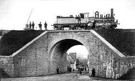
Crossing of Kraichgaubahn and road in Jöhlingen, 1879
Walzbachtal is a town in northwestern Karlsruhe district in Baden-Württemberg, Germany.
References
- ↑ "Bevölkerung nach Nationalität und Geschlecht am 31. Dezember 2017". Statistisches Landesamt Baden-Württemberg (in German). 2018.
This article is issued from
Wikipedia.
The text is licensed under Creative Commons - Attribution - Sharealike.
Additional terms may apply for the media files.