Wallis (island)
| Kingdom of ʻUvea Puleʻaga Hau ʻo ʻUvea | |
|---|---|
 Flag
 Coat of arms
| |
.svg.png) | |
| Capital and largest city |
Matāʻutu 13°16′S 176°12′W / 13.267°S 176.200°W |
| Official languages | |
| Demonym | Wallisian |
| Government | Overseas collectivity |
| Kapeliele Faupala | |
• Prime Minister (Kalae Kivalu) | Setefano Hanisi |
• Bishop of Diocese | Ghislain de Rasilly |
| Traditional customary kingdom | |
| 29 July 1961 | |
| Area | |
• Total | 96 km2 (37 sq mi) (211th) |
• Water (%) | negligible |
| Population | |
• 2008 estimate | 10,731 |
• Density | 11,136/km2 (28,842.1/sq mi) |
| Currency | CFP franc |
| Time zone | UTC+12 |
| Driving side | right |
| Calling code | +681 |
| Internet TLD | .wf |
Wallis (Wallisian: ʻUvea) is a Polynesian island in the Pacific Ocean belonging to the French overseas collectivity (collectivité d'outre-mer, or COM) of Wallis and Futuna. It lies north of Tonga, northeast of Fiji, east-northeast of the Hoorn islands, east of Fiji's Rotuma, southeast of Tuvalu, southwest of Tokelau and west of Samoa. Its area is almost 100 km2 (39 sq mi) with almost 11,000 people. Its capital is Matāʻutu. Roman Catholicism is the predominant religion. Its highest point is Mount Lulu Fakahega (131 metres, 430 ft). Wallis is of volcanic origin with fertile soil and some remaining lakes. Rainfall is plentiful.
Geography
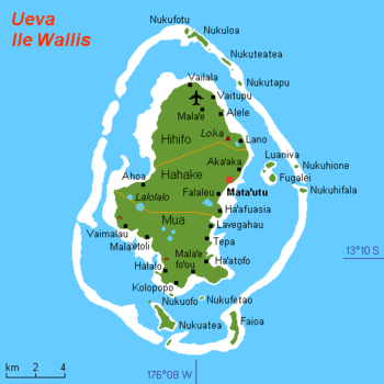
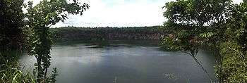
The island has an area of 77.5 km2 (29.9 sq mi) and a circumference of c. 50 km (31 mi). Its highest point is Mount Lulu Fakahega, which rises 131 metres (430 ft). There are also a few large lakes such as Lake Lalolalo. These crater lakes attest to the island's volcanic origin. Some of the lakes, such as Lalolalo and Lanu'tavake appear as almost perfect circles with straight vertical walls.
Wallis Island is located 240 km (150 mi) northeast of Futuna and Alofi islands which form the Hoorn archipelago. Together with some 15 smaller islands surrounding it, on its huge barrier reef, it forms the Wallis archipelago. Wallis has a fertile volcanic soil and sufficient rainfall to allow subsistence farming.
Wallis is subdivided into three districts (north to south):
- Hihifo: 5 Villages : Vailala, Tufuone, Vaitupu, Malae, and Alele.
- Hahake : 6 Villages : Liku, Aka'aka, Mata-Utu, Ahoa, Falaleu, and Ha'afuasia.
- Mu'a : 10 Villages : Lavegahau, Tepa, Gahi, Ha’atofo, Mala’efo’ou, Kolopo, Halalo, Utufua, Vaimalau, and Teesi.
| District ("meaning") | Capital | Area (km²) | Population (2003 census) | Villages |
|---|---|---|---|---|
| Hihifo ("West") | Vaitupu | 23.4 | 2422 | 5 |
| Hahake ("East") | Matāʻutu | 27.8 | 3950 | 6 |
| Mu'a ("First") | Mala'efo'ouA | 26.3 | 3699 | 10 |
| 'Uvea (Wallis) chiefdom | Matāʻutu | 77.5 | 10071 | 21 |
A Formerly called "Mua".
Sub-equatorial oceanic trade winds make the island hot and humid. The average temperature is around 26 °C (79 °F) all year round and there is almost never drops below 24 °C (75 °F), and in the rainy season is held in the mark 28–32 °C (82–90 °F).
Rainfall is 2,500–3,000 mm (98–118 in) per year, up to 4,000 mm (160 in) in Wallis and Futuna. This rain is likely at least 260 days in a year, and the humidity is 80%. The rainy season lasts from November to April. The same period (November to March), the season of storms, is associated with the passage over the territory of the islands of powerful tropical cyclones. It is followed, in May to October–December, by a cooler and drier season because of the predominance in this period of the southeast trade winds.
History
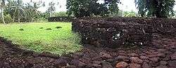
Archaeological excavations have identified sites on Wallis dating from circa 1400 AD. It was part of the Tongan maritime empire from around the 13th to 16th century. By that time the influence of the Tuʻi Tonga had declined so much that ʻUvea became important in itself. Several current, high-ranking Tongan titles, like Halaevalu, trace their descent from ʻUvea. A legendary large canoe, the Lomipeau, was built on the island as a donation to the Tuʻi Tonga. The big fortress of Talietumu close to Lotoalahi in Mua was the last holdout of the Tongans until they were defeated. The ruins of the place are still a tourist attraction.
The island was renamed "Wallis" after a Cornish navigator, Captain Samuel Wallis, who saw it while sailing aboard HMS Dolphin on 16 August 1767, following his discovery of Tahiti.[1]
On 5 April 1842, the authorities of Wallis Island requested protection by France with a protectorate treaty signed in April 1887.[2]
During World War II the island's administration was pro-Vichy until a Free French corvette from New Caledonia deposed the regime on 26 May 1942. Units of the US Marine Corps landed on Wallis on 29 May 1942.[3]
After a referendum in 1959, Wallis became a French Overseas Territory in 1961.
Demographics
The population of the island was 10,071 in 2003 (67% of the territory's population). Most of the inhabitants speak ʻUvean (or Wallisian) as their mother tongue.
Culture and religion
Religion ("Lotu") and culture ("Aga'ifenua") are very close in Wallis. Everyday life is heavily influenced by Polynesian traditions and especially by the Roman Catholic feasts. Each village has its own patron saint. Each district has its great church. The chief cathedral is the Cathedral of Mata-Utu. Almost all the people are Roman Catholic ("Lotu Katolika"), and there are numerous religious buildings on the island.
At their arrival, Catholic missionaries were welcomed by the King Vaimua Lavelua then baptized "Soane-Patita Vaimua". Bishop Bataillon developed close relationships with the royal families. As Private Councillor of Queen Amelia, he established in 1847 the Lano Seminary (the first Catholic seminary of Oceania).
Lano celebrated 150 years in 1997. The anniversary was attended by Samoan Cardinal Pio Taofinu'u, who studied there in the 1940s, and a big delegation from Tonga, Samoa, Fiji and New-Caledonia.
Wallis and Futuna was established as an Apostolic Vicariate on 11 November 1935 and promoted to a Diocese on 21 June 1966.
Transportation
The only commercial flights that go to Wallis are operated by the New Caledonia-based Aircalin. There is an Aircalin office in Matāʻutu in Hahake.
Education
The island has 12 primary schools,[4] four junior high schools, and one senior high school/sixth-form college.[5]
- Junior high schools (collèges) in Wallis: Mataotama de Malae, Alofivai de Lano, Vaimoana de Lavegahau, and Tinemui de Teesi
- The senior high school/sixth-form college is Lycée d'Etat de Wallis et Futuna on Wallis
See also
Notes
- ↑ Hawkesworth et al, Volume 1, p 498
- ↑ http://www.discoverfrance.net/Colonies/Wallis_Futuna2.shtml
- ↑ p.213 Rottman, Gordon L. U.S. Marine Corps World War II Order of Battle: Ground and Air Units in the Pacific War, 1939-1945 Greenwood Publishing Group, 2002
- ↑ "LIVRET D'ACCUEIL Wallis et Futuna." Wallis and Futuna. p. 22 (22/28). Retrieved on September 14, 2016.
- ↑ "Cartographie des établissements du second degré." Wallis and Futuna. June 24, 2016. Retrieved on September 14, 2016.
References
- E.G. Burrows, Ethnology of Uvea, BPB 1937.
- "Wallis Islands". Global Volcanism Program. Smithsonian Institution.
- Hawkesworth, John; Byron, John; Wallis, Samuel; Carteret, Philip; Cook, James; Banks, Joseph (1773), An account of the voyages undertaken by the order of His present Majesty for making discoveries in the Southern Hemisphere, and successively performed by Commodore Byron, Captain Wallis, Captain Carteret, and Captain Cook, in the Dolphin, the Swallow, and the Endeavour drawn up from the journals which were kept by the several commanders, and from the papers of Joseph Banks, esq, London Printed for W. Strahan and T. Cadell , Volume I, Volume II-III
External links
- French world linguistics site
- Map showing details of Wallis Island
- Pictures of Wallis
- Flag of `Ueva chiefdom
- Wallis Wordlist at the Austronesian Basic Vocabulary Database
Wallis and Futuna articles | |||
|---|---|---|---|
| Islands |  | ||
| Chiefdoms | |||
| Geography | |||
| Politics | |||
| Economy | |||
| Culture | |||
| |||