Walligan
| Walligan Queensland | |||||||||||||||
|---|---|---|---|---|---|---|---|---|---|---|---|---|---|---|---|
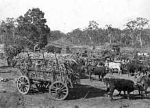
 Farm workers at Walligan railway siding, 1924 | |||||||||||||||
 Walligan | |||||||||||||||
| Coordinates | 25°20′09″S 152°46′14″E / 25.3358°S 152.7705°ECoordinates: 25°20′09″S 152°46′14″E / 25.3358°S 152.7705°E | ||||||||||||||
| Postcode(s) | 4655 | ||||||||||||||
| Elevation | 10 m (33 ft) | ||||||||||||||
| Area | 26.8 km2 (10.3 sq mi) | ||||||||||||||
| LGA(s) | Fraser Coast Region | ||||||||||||||
| State electorate(s) | Maryborough | ||||||||||||||
| Federal Division(s) | |||||||||||||||
| |||||||||||||||
Walligan is a locality in the Fraser Coast Region, Queensland, Australia.[1]
Geography
Walligan is relatively flat land approximately 10 metres above sea level. Approximately half of the land is developed freehold land and is used as acreage blocks for semi-rural residences with some agricultural use. The remainder still in government ownership, much of it being part of the Vernon Conservation Park which occupies 684 hectares (6.84 km2).[2][3]
History
The Hervey Bay railway line opened in 1896 passing through Walligan where there was a railway station. Passenger services ended in 1973 but the line continue to be used for freight until the line's closure in 1993. It is now used as a mobility corridor for pedestrians, cyclists and mobility scooters.[4]
References
- ↑ "Walligan - locality in Fraser Coast Region (entry 46690)". Queensland Place Names. Queensland Government. Retrieved 29 December 2017.
- ↑ "Queensland Globe". State of Queensland. Retrieved 28 February 2018.
- ↑ "Vernon Conservation Park - conservation park in Fraser Coast Region (entry 39666)". Queensland Place Names. Queensland Government. Retrieved 28 February 2018.
- ↑ Seymour, George (16 January 2018). "Hervey Bay's old railway line is now the mobility corridor". Fraser Coast Chronicle. Archived from the original on 28 February 2018. Retrieved 28 February 2018.
External links
![]()