Walkertshofen
| Walkertshofen | ||
|---|---|---|
| ||
 Walkertshofen Location of Walkertshofen within Augsburg district 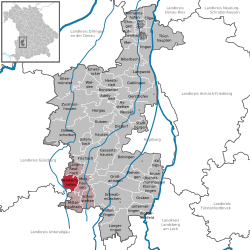 | ||
| Coordinates: 48°14′N 10°35′E / 48.233°N 10.583°ECoordinates: 48°14′N 10°35′E / 48.233°N 10.583°E | ||
| Country | Germany | |
| State | Bavaria | |
| Admin. region | Schwaben | |
| District | Augsburg | |
| Government | ||
| • Mayor | Margit Jungwirth-Karl | |
| Area | ||
| • Total | 12.68 km2 (4.90 sq mi) | |
| Elevation | 535 m (1,755 ft) | |
| Population (2017-12-31)[1] | ||
| • Total | 1,089 | |
| • Density | 86/km2 (220/sq mi) | |
| Time zone | CET/CEST (UTC+1/+2) | |
| Postal codes | 86877 | |
| Dialling codes | 08239 | |
| Vehicle registration | A | |
| Website | www.walkertshofen.de http://citypopulation.info/php/germany-bayern.php?cityid=09772214 | |

Walkertshofen is a municipality in the district of Augsburg in Bavaria in Germany. It is set amongst gentle rolling hills of the farm district of Bavaria that are occasionally covered in snow during the winter months. Its only source of retail is one public hotel for food and refreshments. The majority of the population in the past have been mainly engaged in the workings of the surrounding farms with a small portion working on the building of the autobahns (main highways).
Within the centre of the town is a monument dedicated to those who lived within the town and lost their lives as a result of the European conflict.
The current population of Walkertshofen is 1,100. This population consists of mainly Roman Catholics
References
- ↑ "Fortschreibung des Bevölkerungsstandes". Bayerisches Landesamt für Statistik und Datenverarbeitung (in German). September 2018.
| Authority control |
|---|
This article is issued from
Wikipedia.
The text is licensed under Creative Commons - Attribution - Sharealike.
Additional terms may apply for the media files.