Waiau River (Canterbury)
| Waiau Uwha | |
| River | |
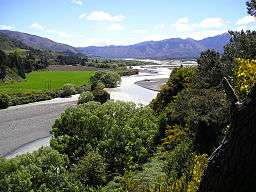 Waiau Uwha River upstream from the Waiau Ferry Bridge, near Hanmer Springs | |
| Country | New Zealand |
|---|---|
| Region | Canterbury |
| District | Hurunui |
| Tributaries | |
| - left | Leader River |
| - right | Hope River |
| City | Hanmer Springs, Waiau, Parnassus |
| Source | Southern Alps |
| - location | Spenser Mountains, New Zealand |
| - coordinates | 42°6′39″S 172°38′42″E / 42.11083°S 172.64500°E |
| Mouth | Pacific Ocean |
| - elevation | 0 m (0 ft) |
| - coordinates | 42°46′15″S 172°22′45″E / 42.77083°S 172.37917°ECoordinates: 42°46′15″S 172°22′45″E / 42.77083°S 172.37917°E |
| Basin | 3,310 km2 (1,278 sq mi) |
.png) Waiau River system | |
| Wikimedia Commons: Waiau River, Canterbury | |
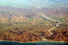
The Waiau river in November 2015
Waiau Uwha River, previously known as the Waiau River, is a river in north Canterbury in the South Island of New Zealand. The Waiau Uwha River rises in the Spenser Mountains and flows eastward to the Pacific Ocean. The Waiau Uwha River has the second largest catchment—3,310 square kilometres (1,280 sq mi)—of North Canterbury's rivers.[1]
In 2018, the name of the river was officially changed from Waiau River to Waiau Uwha River, to reflect its original Māori name.[2]
References
- ↑ Robert Logan, Waimakariri. The story of Canterbury's "river of cold rushing water". ISBN 0-473-00520-4, Robert Logan, Christchurch, 1987, page 6.
- ↑ "Waiau Uwha River". Land Information New Zealand. 18 January 2018. Retrieved 30 January 2018.
External links

This article is issued from
Wikipedia.
The text is licensed under Creative Commons - Attribution - Sharealike.
Additional terms may apply for the media files.