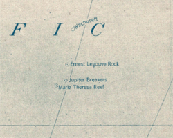
Wachusett Reef
| Wachusett Reef | |
|---|---|
 Wachusett Reef on 1921 Pacific map | |
| Type | Phantom island |
Captain Lambert of the ship Wachusett reported that on June 4, 1899 he passed over a reef which appeared to be of coral formation in approximately latitude 32°18′S 151°08′W / 32.300°S 151.133°W. The reef appeared to be about 500 feet wide. The bottom showed of a dark gray color with deep blue on both sides of the reef. The depth was estimated at from 5 to 6 fathoms; unfortunately no soundings were taken.[1]
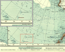
The 2015 edition of the National Geographic Atlas of the World still shows Wachusett Reef, with a depth of 9 meters.[2] Nevertheless, its existence is doubtful, making it a phantom reef. Other nearby historically reported reefs which appear to not exist include Ernest Legouve Reef, Jupiter Reef, and Maria Theresa Reef.
Notes
- ↑ United States Hydrographic Office (1916). Pacific Islands Pilot, v. 2. Washington, D.C.: Government Printing Office. p. 56. Retrieved 2011-09-26.
- ↑ National Geographic Atlas of the World (10th ed.). Washington, D.C.: National Geographic. 2015. p. plate 109. ISBN 1-4262-1354-9.
References
![]()
- Eade, J.V. (1976). Geological notes on the Southwest Pacific Basin in the area of Wachusett Reef and Maria Theresa Reef. Wellington: New Zealand Oceanographic Institute.