WSR-57

WSR-57 radars were the USA's main weather surveillance radar for over 35 years.[1] The National Weather Service operated a network of this model radar across the country, watching for severe weather.
History

The WSR-57 (Weather Surveillance Radar - 1957) was the first 'modern' weather radar. Initially commissioned at the Miami Hurricane Forecast Center, the WSR-57 was installed in other parts of the CONUS (continental United States).[2] The WSR-57 was the first generation of radars designed expressly for a national warning network.[3]
The WSR-57 was designed in 1957 by Dewey Soltow using World War II technology. It gave only coarse reflectivity data and no velocity data, which made it extremely difficult to predict tornadoes.[2] Weather systems were traced across the radar screen using grease pencils. Forecasters had to manually turn a crank to adjust the radar's scan elevation, and needed considerable skill to judge the intensity of storms based on green blotches on the radar scope.[1]
The military designation for the WSR-57 is AN/FPS-41.[2]
NOAA has pictures of the Charleston, SC, WSR-57 radar image of the 1989 Hurricane Hugo. A WRS-57 dish, located on the roof of the National Hurricane Center (NHC), was blown away by Hurricane Andrew. The NHC report on Hurricane Andrew shows its last radar image, as well as images from nearby WSR-88D radars. As the network of WSR-57 radars aged, some were replaced with WSR-74S models of similar performance but with better reliability. WSR-57 operators sometimes had to scramble for spare parts no longer manufactured in this country.[1] 128 of the WSR-57 and WSR-74 model radars were spread across the country as the National Weather Service's radar network until the 1990s.[4] The WSR-57 radars were gradually replaced by the Weather Surveillance Radar - 1988, Doppler, WSR-88D, which NOAA named the NEXRAD network.
The last WSR-57 radar in the United States was decommissioned on December 2, 1996.[1]
Radar sites
The 66[1] former sites of the WSR-57 include[2][5][6][7] the following:
| Site (Site ID) | Commissioned (Date / Chronological Rank) | Decommissioned |
|---|---|---|
| Miami, FL (MIA) Moved to Coral Gables in 1967. |
June 26, 1959 1st |
August 24, 1992 Destroyed during Hurricane Andrew. |
| Kansas City, MO (MCI) The dome still resides downtown. |
1959 2nd |
November 9, 1995 |
| Charleston, SC (CHS)[1] | August 12, 1960
About 16th |
December 2, 1996 |
| Key West, FL (EYW?) | Early 1960 Among first 31 |
Early 1980s Replaced by a WSR-74S. |
| Wichita, KS (ICT) | June 22, 1960 Among first 31 |
November 9, 1995 |
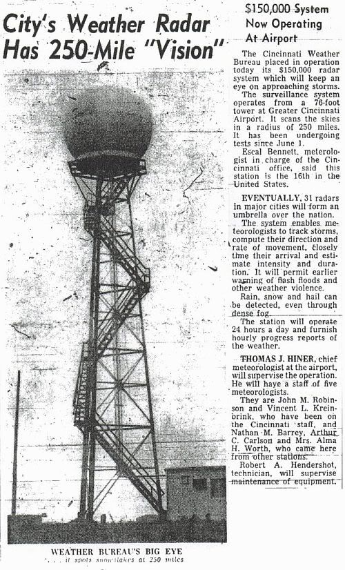
| Cincinnati, OH (CVG) (Covington, KY) at the Greater Cincinnati Airport. |
1960 (testing in June) About 16th |
June 21, 1996 |
| St. Louis, MO (STL) | July 1960 Among first 31 |
June 19, 1996 |
| Wilmington, NC (ILM) | Before September 1960 Among first 31 |
November 16, 1995 |
| Tampa Bay Area, FL (TBW) | 1960 Among first 31 |
November 9, 1995 |
| Galveston, TX (GLS) | 1960 Among first 31 |
May 22, 1995 |
| Brownsville, TX (BRO) | March 1961 About 16th |
February 28, 1996 |
| Fort Worth, TX (FTW) moved to Stephenville, TX (SEP) in October 1973. |
April 5, 1961 Among first 31 |
August 1, 1995 |
| Detroit, MI | September 12, 1961[8]
Among first 31 |
Replaced with a WSR-74S. |
| Amarillo, TX (AMA) | 1961 Among first 31 |
September 15, 1994 |
| Norman, OK - NSSL Research radar; not part of the national network. |
1962? Probably not counted among first 31 |
1980s |
| Catalina Island, CA (STC?) a.k.a. Santa Catalina - atop Blackjack Mountain. |
Early 1963? Among first 31 |
1960s |
| Little Rock, AR (LIT was the WSR-57 designator. LZK is the WSR-88D and WFO Designation.) | 1959 Among first 31 |
Moved to North Little Rock Airport with NWSFO in 1975. Final decommissioning was June 8, 1995 |
| Sacramento, CA (SAC) | Early 1960s Among first 31 |
August 24, 1995 |
| Washington, D.C. (IAD) At Washington Dulles International Airport, Dulles, VA. |
Early 1960s Among first 31 |
Early 1980s Replaced by a WSR-74S at Patuxent River, MD. |
| Apalachicola, FL (AQQ) | Early 1960s Among first 31 |
January 19, 1996 |
| Daytona Beach, FL (DAB) | Early 1960s Among first 31 |
December 1, 1995 |
| Des Moines, IA (DSM) | Early 1960s Among first 31 |
May 7, 1996 |
| Chicago, IL (?) | Early 1960s Among first 31 |
Early 1980s Replaced by a WSR-74S at Marseilles, IL |
| Evansville, IN (EVV) | Early 1960s Among first 31 |
July 12, 1996 |
| Lake Charles, LA (LCH) | Early 1960s Among first 31 |
October 12, 1995 |
| New Orleans, LA (MSY) At Slidell, LA |
Early 1960s Among first 31 |
August 22, 1995 |
| Minneapolis, MN (MSP) At the airport |
Early 1960s Among first 31 |
April 3, 1996 |
| Missoula, MT (MSO) At Point Six Mountain |
Early 1960s Among first 31 |
December 12, 1995 |
| Atlantic City, NJ (ACY) | Early 1960s Among first 31 |
September 13, 1995 |
New York City, NY (NYC) |
Early 1960s Among first 31 |
September 26, 1995 |
| Oklahoma City, OK (OKC) | Early 1960s Among first 31 |
July 25, 1994 |
| Portland, ME (?) At Brunswick Naval Air Station |
November 1969 | Replaced by a WSR-74S. |
| Jackson, MS (JAN) At Jackson International Airport at Thompson Field. |
1969 | June 21, 1995 |
| Limon, CO (LIC) | 1960s | December 22, 1995 |
| Garden City, KS (GCK) | 1960s | September 1, 1994 |
| Grand Island, NE (GRI) | 1960s | January 19, 1996
Has been torn down to make way for a new airport termial |
| Buffalo, NY (BUF) | October 29, 1961 | February 14, 1996 |
| A note on the chronological ranks - The first 31 were built through the early 1960s, at existing Weather Bureau offices. 14 were along the Gulf and Atlantic coasts. 11 were in the Midwest. 3 were inland of the East Coast, and California and Montana had one each on mountaintops. The late 1960s saw 14 more built east of the Rockies. | ||
| Nashville, TN (OHX) At Old Hickory Lake |
October 31, 1970 1970 | January 19, 1996 |
| Memphis, TN (MEG?) At the Millington Naval Air Station. |
February 1971 | December 1985 Replaced by a WSR-74S. |
| Medford, OR (MFR) | June 1971 | August 30, 1996 |
| Centreville, AL (CKL) |
1970 | June 27, 1995 |
| Pensacola, FL (PNS/NPA) | January 19, 1996 | |
| Athens, GA (AHN) | June 21, 1966 | September 13, 1996 |
| Waycross, GA (AYS) | January 19, 1996 | |
| Cape Hatteras, NC (HAT) | December 6, 1995 | |
| Pittsburgh, PA (PBZ) | May 10, 1995 | |
| Huron, SD (HON) | October 30, 1971 [9] | November 4, 1996, now a live dual-polarization for KELO-TV |
| Bristol, TN (TRI) | May 25, 1972 | January 19, 1996 |
| Midland/Odessa, TX (MAF) | June 4, 1996 | |
| Neenah, WI (EEW) | June 28, 1971 | November 2, 1995 |
| Hondo, TX (HDO) | July 1971[10] Last (66th) |
March 14, 1996 |
Radar properties

- The radar uses a wavelength of 10.3 cm.[11] This corresponds to an operating frequency of 2890 MHz. This frequency is in the S band, which is also used by today's weather radar network.
- WSR-57 radars had the following interesting statistics:[11]
- Dish diameter: 12 feet (3.7 m)
- Power output: 410,000 watts
- Maximum range: 915 km (494 nm)
References
- 1 2 3 4 5 6 "Weather service retires last of old radars". USAToday. Archived from the original on February 23, 2002. Retrieved 2018-06-10.
- 1 2 3 4 "History of Operational Use of Weather Radar by U.S. Weather Services". AMS. Retrieved 2008-03-27.
- ↑ "Historic Tornado Warning Conference Launched Nation's First Weather Radar Network". NOAA. Retrieved 2008-03-27.
- ↑ "An Overview of NEXRAD Products Available via UCAR's Unidata Program". wsicorp.com. Archived from the original on April 20, 2008. Retrieved 2008-03-27.
- ↑ "Assessment of Nexrad Coverage and Associated Weather Services (1995)". books.nap.edu. Retrieved 2008-03-27.
- ↑ "Report of US Weather Bureau Studies in Radar Hydrology" (PDF). cig.ensmp.fr. Retrieved 2008-03-27.
- ↑ "NWS Offices Past and Present". dm.net. Archived from the original on 2007-09-28. Retrieved 2008-03-27.
- ↑ National Weather Service Detroit/Pontiac Forecast Office. "Beecher 50th Anniversary Commemoration". National Weather Service Central Region Headquarters. Retrieved 2014-06-26.
- ↑ https://www.newspapers.com/newspage/21670634
- ↑ "HONDO, TEXAS". utexas.edu. Retrieved 2008-03-27.
- 1 2 "WSR - Weather Surveillance Radar". weather.cod.edu. Retrieved 2008-03-27.