Węgliniec
| Węgliniec | |||
|---|---|---|---|
 Railway station | |||
| |||
 Węgliniec  Węgliniec | |||
| Coordinates: 51°17′18″N 15°13′32″E / 51.28833°N 15.22556°ECoordinates: 51°17′18″N 15°13′32″E / 51.28833°N 15.22556°E | |||
| Country |
| ||
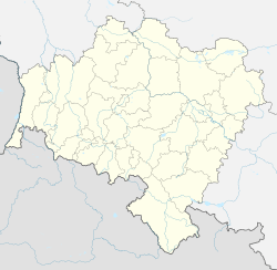
| Voivodeship |
| ||
| County | Zgorzelec | ||
| Gmina | Węgliniec | ||
| Government | |||
| • Mayor | Stanisław Mikołajczyk | ||
| Area | |||
| • Total | 8.71 km2 (3.36 sq mi) | ||
| Population (2006) | |||
| • Total | 3,072 | ||
| • Density | 350/km2 (910/sq mi) | ||
| Time zone | UTC+1 (CET) | ||
| • Summer (DST) | UTC+2 (CEST) | ||
| Postal code | 59-940 | ||
| Car plates | DZG | ||
| Climate | Cfb | ||
| Website | http://www.wegliniec.pl | ||

Węgliniec [vɛŋˈɡliɲɛt͡s] (German: Kohlfurt) is a town in Zgorzelec County, Lower Silesian Voivodeship, in south-western Poland. It is the seat of the administrative district (gmina) called Gmina Węgliniec. Before 1945, the village was in Germany and known as Kohlfurt.
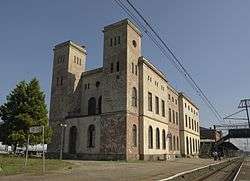
Węgliniec railway station remains a major railway junction, located on strategic passenger and freight routes between Poland & Germany, with regular cross-border passenger services to Görlitz/Dresden and a limited service to Cottbus/Berlin.
The town lies approximately 22 kilometres (14 mi) north-east of Zgorzelec, and 128 kilometres (80 mi) west of the regional capital Wrocław.
As at 2006, the town has a population of 3,072.
See also
| Town and seat |  | |
|---|---|---|
| Villages |
| |
This article is issued from
Wikipedia.
The text is licensed under Creative Commons - Attribution - Sharealike.
Additional terms may apply for the media files.