Wölpe
| Wölpe | |
|---|---|
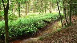 The Wölpe near the Brunsburg by Heemsen | |
| State | Lower Saxony, Germany |
| Physical characteristics | |
| Main source |
east of Nienburg/Weser 26 m above sea level (NN) 52°39′26″N 9°14′58″E / 52.6571°N 9.2494°E |
| River mouth |
near Rethem into the Aller 18 m above sea level (NN) 52°46′38″N 9°21′52″E / 52.7772°N 9.3644°ECoordinates: 52°46′38″N 9°21′52″E / 52.7772°N 9.3644°E |
| Length | 16.6 km (10.3 mi) [1] |
| Basin features | |
| Progression | Alpe→ Aller→ Weser→ North Sea |
| Landmarks |
|
| Tributaries |
|
The Wölpe is a left tributary of the river Alpe in the German state of Lower Saxony and is about 17 km long. It has its source in a depression southeast of Erichshagen-Wölpe, a village in the borough of Nienburg/Weser and flows towards the northeast. In front of Rethem the Weiße Graben ("White Ditch") links the Wölpe with the Alpe. The Alpe-Wolpe-Umfluter then discharges into the Aller near Wohlendorf in the borough of Rethem. The waterway has been considerably straightened. It flows through woods, grassland and cultivated fields. According to the 2000 Water Quality Chart issued by the NLWKN it is critically polluted throughout (quality class II−III).[2]
History
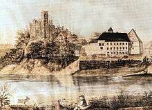
At about 0.8 kilometres from the source near the Nienburg village of Erichshagen-Wölpe the river Wölpe flows by the mound on which the former castle of the counts of Wölpe stood. During the Middle Ages the waterway was widened into a moat for the security of the fortified position and flowed around the castle built in the 12th century. After the destruction of the site in the 17th century the castle moat and the Wölpe were filled with rubble.
About 4 km further on near Heemsen the Wölpe flows into the wood by the site of the 9th century Brunsburg castle. Here, too, the stream was probably used as part of the defences.