Voyager Point, New South Wales
| Voyager Point Sydney, New South Wales | |||||||||||||||
|---|---|---|---|---|---|---|---|---|---|---|---|---|---|---|---|
 The Sanctuary, Voyager Point | |||||||||||||||
| Population | 1,668 (2016 census)[1] | ||||||||||||||
| Established | 1987 | ||||||||||||||
| Postcode(s) | 2172 | ||||||||||||||
| Location | 25 km (16 mi) South of Sydney CBD | ||||||||||||||
| LGA(s) | Liverpool | ||||||||||||||
| State electorate(s) | Holsworthy | ||||||||||||||
| Federal Division(s) | Hughes | ||||||||||||||
| |||||||||||||||
Voyager Point is a small suburb, in Western Sydney, in the state of New South Wales, Australia. Voyager Point is located 25 kilometres (35 min) south of the Sydney central business district, in the local government area of the City Of Liverpool. The only adjacent suburbs are Sandy Point, Holsworthy and Pleasure Point. Milperra, Panania and East Hills are located on the opposite bank of the Georges River. In the 2011 census, Voyager Point recorded a population of 1,369 people.
History
Voyager Point takes its name from the commemorative park which was established following the loss of HMAS Voyager with the loss of 82 lives after the destroyer collided with the aircraft carrier HMAS Melbourne in February 1964.[2] This area was formerly the East Hills Naval Estate, which contained about 70 married quarters for families of members in the Royal Australian Navy.
Heritage listings
Voyager Point has a number of heritage-listed sites, including:
- Creekwood Reserve: Lucas Watermills Archaeological Sites[3]
Landmarks
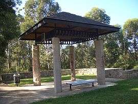
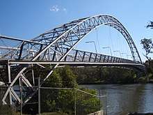
The area includes many native flora, fauna and walkways through the bushland areas. A footbridge across the Georges River connects the suburb to East Hills, near Henry Lawson Drive. The Avenue is the only access road into the suburb from Heathcote Road.
Streets
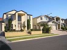
The original streets in the suburb, such as Torch and Pelorus, were named after ships of the Second Fleet. The suburb is a relatively new development by Delfin Lend Lease on land formerly belonging to Holsworthy Barracks.
References
- ↑ Australian Bureau of Statistics (27 June 2017). "Voyager Point (State Suburb)". 2016 Census QuickStats. Retrieved 15 January 2018.

- ↑ "Voyager Point". Geographical Names Register (GNR) of NSW. Geographical Names Board of New South Wales.
- ↑ "Lucas Watermills Archaeological Sites, New South Wales State Heritage Register (NSW SHR) Number H01989". New South Wales State Heritage Register. Office of Environment and Heritage. Retrieved 18 May 2018.
Coordinates: 33°57′32″S 150°58′44″E / 33.959°S 150.979°E
| Wikimedia Commons has media related to Voyager Point, New South Wales. |