Niederstetten
| Niederstetten | ||
|---|---|---|
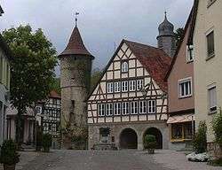 Town hall | ||
| ||
 Niederstetten Location of Niederstetten within Main-Tauber-Kreis district 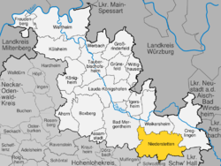 | ||
| Coordinates: 49°24′03″N 09°55′05″E / 49.40083°N 9.91806°ECoordinates: 49°24′03″N 09°55′05″E / 49.40083°N 9.91806°E | ||
| Country | Germany | |
| State | Baden-Württemberg | |
| Admin. region | Stuttgart | |
| District | Main-Tauber-Kreis | |
| Government | ||
| • Mayor | Rüdiger Zibold | |
| Area | ||
| • Total | 104.06 km2 (40.18 sq mi) | |
| Elevation | 306 m (1,004 ft) | |
| Population (2017-12-31)[1] | ||
| • Total | 4,847 | |
| • Density | 47/km2 (120/sq mi) | |
| Time zone | CET/CEST (UTC+1/+2) | |
| Postal codes | 97996, 97980 (Mönchshof) | |
| Dialling codes | 07932, 07933, 07939 (Heimberg) | |
| Vehicle registration | TBB, MGH | |
| Website | www.niederstetten.de | |

| Wikimedia Commons has media related to Niederstetten. |
Niederstetten is a town and a municipality in the Main-Tauber district, in Baden-Württemberg, Germany. It is situated 14 km southeast of Bad Mergentheim, and 19 km west of Rothenburg ob der Tauber.
Sights
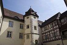
Inner courtyard of castle Haltenbergstetten
The main attraction is the Castle Haltenbergstetten.
Museum
The Albert-Sammt-Zeppelin-Museum is in memory of last German airship captain Albert Sammt and shows original parts as well as documents of Zeppelin history.
Economy, industry and infrastructure
Military
Niederstetten is home to German Army Aviation Transport Helicopter Regiment 30 based at Niederstetten Air Base.
International relations
Niederstetten is twinned with:
References
- ↑ "Bevölkerung nach Nationalität und Geschlecht am 31. Dezember 2017". Statistisches Landesamt Baden-Württemberg (in German). 2018.
This article is issued from
Wikipedia.
The text is licensed under Creative Commons - Attribution - Sharealike.
Additional terms may apply for the media files.