Igersheim
| Igersheim | ||
|---|---|---|
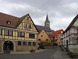 Town hall and church | ||
| ||
 Igersheim Location of Igersheim within Main-Tauber-Kreis district 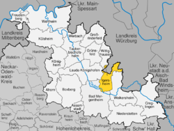 | ||
| Coordinates: 49°29′35″N 09°49′00″E / 49.49306°N 9.81667°ECoordinates: 49°29′35″N 09°49′00″E / 49.49306°N 9.81667°E | ||
| Country | Germany | |
| State | Baden-Württemberg | |
| Admin. region | Stuttgart | |
| District | Main-Tauber-Kreis | |
| Government | ||
| • Mayor | Frank Menikheim | |
| Area | ||
| • Total | 42.84 km2 (16.54 sq mi) | |
| Elevation | 212 m (696 ft) | |
| Population (2017-12-31)[1] | ||
| • Total | 5,561 | |
| • Density | 130/km2 (340/sq mi) | |
| Time zone | CET/CEST (UTC+1/+2) | |
| Postal codes | 97999, 97957 (Bowiesen) | |
| Dialling codes | 07931, 09336 (Bernsfelden, Simmringen), 09347 (Bowiesen) | |
| Vehicle registration | TBB, MGH | |
| Website | www.igersheim.de | |

Igersheim is a town in the Main-Tauber district in the German state of Baden-Württemberg.
History
Igersheim is mentioned in chronicles as early as 1090. Since 1972 Bernsfelden, Harthausen, Neuses and Simmringen belong to Igersheim.
Inhabitants
- 1880: 982
- 2005: 5.709
- 2013: 5.504
Sights
Johann-Adam-Möhler-Haus
In this house Johann Adam Möhler was born. He is one of the famous people from Igersheim.
Burg Neuhaus castle
It was built in the 13th century. The 1st documentation of the castle dates the year 1281. It was destroyed and rebuilt in both the German Peasants' War and the Schmalkaldic War.
Today it is a place for horse breeding and middle age reenactment events.
References
- ↑ "Bevölkerung nach Nationalität und Geschlecht am 31. Dezember 2017". Statistisches Landesamt Baden-Württemberg (in German). 2018.
Towns and municipalities in Main-Tauber (district) | ||
|---|---|---|
This article is issued from
Wikipedia.
The text is licensed under Creative Commons - Attribution - Sharealike.
Additional terms may apply for the media files.