Volcanoes of east-central Baja California
The volcanoes of east-central Baja California are located on the Baja California Peninsula near the Gulf of California, in the state of Baja California Sur, in Mexico.
Geography
Physical features
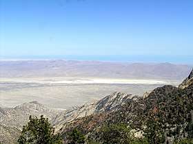
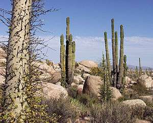
Baja California is a peninsula in Mexico, bordering the Pacific Ocean and the Gulf of Mexico. It is made up primarily of mountains, and some coastal plains. The mountain ranges in Baja California, connected to the Pacific Coast Ranges, extend from the north-eastern to the south-western part of the peninsula.[1] Out of the 24 named ranges, the Sierra de Juárez and the Sierra San Pedro Mártir, the highest range in Baja California, are the two most significant. The slopes of the ranges vary depending on location; the slopes on the western side are gentler than those on the east. Coastal plains are mostly found in the south-west regions on the peninsula. In the center of Baja California, volcanic activity is found mostly near the San Ignacio area.[2] The landscape is a patchwork of lava flows and the hardened remains of pyroclastic flows – hot clouds of volcanic ash, dust, and rock fragments that race down the slopes of a volcano like an avalanche.
Rivers
The majority of the rivers and streams in Baja California, such as San Benito, San Miguel and Raymundo, lead back to the Pacific Ocean. The San Ignacio River, however, which is the longest river in the peninsula, leads to the Ballenas Bay.[2]
Climate
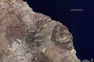
In general, Baja California's climate is hot, dry, and mainly desert. The north and the south receive much more rain than the central regions, which only occasionally receive a small amount of rain in the summer while staying mostly dry. As for the coasts of the peninsula, temperatures on the west are very different than those of the east. Due to the cold water coming from the north with the California Current, the west coast is much cooler than the east and south, which stay rather warm in the winter time as well.[3] The arid climate of Baja California limits the amount of vegetation covering the ground and allows the dramatic volcanic features of the landscape to stand out in this natural-color image from the Landsat 7 satellite on October 5, 2000.
La Reforma Caldera
La Reforma Caldera is a volcano that is on the east-central Baja California. It is about 10 km (6.2 mi) in diameter and at about an elevation of 1,300 m (4,300 ft).[4] In the east-central Baja California there are several volcanoes and this one lies east of the Tres Vírgenes volcano and SE of El Aguajito. There are several things that distinguishes the differences between these volcanoes and one of the things are the type of volcano it is and the kind of rocks it contains.
La Reformas other aspect that makes it distinguishable is the outer rim it has. The rim is not exposed and is made up of rocks. The dark colored rocks that make up the outer rim of the volcano is made out of very fluid lava.[5]
La Reforma is a caldera volcano, one of the most dangerous types of volcanoes: if it collapses it forms in a way where it collapses into an empty magma chamber forming something that looks like a crater. A caldera volcano is one of the most dangerous for the fact that the eruptions are huge of about 100–1,000 km3 (3.5–35.3 trillion cu ft) of material and has been known as the super volcanic eruptions[6] due to the size of the explosions. La Reformas last huge explosive was recorded about 10,000 years ago. It has been recorded that the eruptions have consisted of ash and pumice falls, pumice flows, and pantellerite tuffs.[7]
Tres Vírgenes
The "Tres Vírgenes", a line of three connected volcanoes, collectively known by that name, are west of La Reforma Caldera. Specifically, the Tres Vírgenes lie along the NE-SW eastern Gulf of California with a tectonic setting of rift zones, that are more than 25 km deep within the continental crust, and continue towards active seafloor spreading.[8] La Vírgen, in the southwest, El Azufre in the center, and El Viejo in the northeast and considering its name, is the oldest lowest peak. La Vírgen is the youngest andesitic stratovolcano of all three. While it has the highest peak, it also has a large amount of dacite lava domes. As well as flanks that have a lava flow, thus causing it to be an andesitic volcano. Considering La Vírgen is the youngest volcano, it has had a complex long list of volcanic eruptions. It has a history of pumice eruptions and explosive eruptions consisting of pyroclastic flows, dacitic and andesitic lava flows.
Features and eruption history
The volcanoes get larger and younger from northeast to southwest. They consist of stratovolcanoes, lava domes, and pyroclastic cones. These types of volcanoes form several rock types, some major ones are: andesite, basaltic andesite, and dacite rocks. Dacitic lava domes and flows are composed inside El Viejo and El Azufre.
Unlike other volcanoes in Baja California, the Tres Vírgenes are known for some of the largest stratovolcanoes, meaning that they have layers of erupting products that continue to pile up.[9] While they are some of the largest, the last time one of the volcanoes was active was in 1746, with a possible eruption in 1857.[10] The evidence for the 1746 eruption came from a Spanish priest, who at the time was on a navigation in the Gulf of California. In his report, it was said that there was an ash plume from the effusive eruption, and while no tephra deposits have been discovered, there is evidence of andesitic lava flow that could have came from the 1746 eruption. As recently as 6,500 years ago, La Vírgen experienced a Plinian eruption – a huge, explosive event that produces an enormous column of volcanic rock fragments and gas that reaches into the stratosphere. The eruption produced a column that reached at least 18 kilometers into the air and deposited ash and rock fragments over 500 square kilometers. In later stages of the eruption, pyroclastic flows (pinkish rocks) and lahars (mudflows, grayish rocks) from El Azufre Volcano paved the plain to the north all the way to the Gulf of California.
El Aguajito Caldera
El Aguajito Caldera, also known as "Santa Ana Caldera", is located northeast of the Tres Vírgenes at 27.554°N 112.552°W.[11] The caldera's formation "is associated with the eruption of ignimbrites, K–Ar dated at 0.76±0.06 Ma".[12][13] The rim of the caldera is approximately 10 km (6.2 mi) wide and is not exposed to the surface.[4] There is an active geothermal system with hot springs on the southern side of the caldera.
See also
- Trans-Mexican Volcanic Belt
- List of volcanoes in Mexico
- Category: Natural history of Baja California Sur
- Category: Lava domes
References and further reading
- Volcanoes on Baja California Peninsula at NASA's Earth Observatory. This article incorporates text from this public domain NASA website. The NASA article includes a link to a high-definition version of the image presented here.
- Capra, L.; Macias, J.L.; Espindola, J.M.; Sieb, C. (1998). "Holocene plinian eruption of La Virgen volcano, Baja California, Mexico". Journal of Volcanology and Geothermal Research. 80: 239–266. doi:10.1016/s0377-0273(97)00049-8.
- Hausback, B.P., Stock, J.M., Dmochowski, J.E., Farrar, C.D., Fowler, S.J., Sutter, K., Verke, P., and Winant, C.D. (2000). To be or not to be a caldera—La Reforma caldera, Baja California Sur, Mexico.Geological Society of America, Abstracts with Programs 32(7), A502.
- Garduño-Monroy, V.H.; Vargas-Ledezma, H.; Campos-Enriquez, J.O. (1993). "Preliminary geologic studies of Sierra El Aguajito, Baja California, Mexico: a resurgent-type caldera". Journal of Volcanology and Geothermal Research. 59: 47–58. doi:10.1016/0377-0273(93)90077-5.
- Global Volcanism Program | El Aguajito. N.p., n.d. Web. 10 May 2017.
- "El Aguajito." VolcanoDiscovery: volcanoes worldwide - news, info, photos, and tours to volcanoes and volcanic areas, earthquake information. N.p., n.d. Web. 10 May 2017.
- Miller, Cheryl. "TRES VIRGENES." Baja Realty and Investments. N.p., June 2012. Web. 23 Apr. 2017.
- Minch, John, Edwin Minch, and Jason Minch. Geology of Baja California. N.p., n.d. Web. 10 May 2017.
- Tres Virgenes." Global Volcanism Program. Global Volcanism Program, n.d. Web. 23 Apr. 2017.
- Tres Virgenes Volcano." Volcano Discovery. N.p., n.d. Web. 23 Apr. 2017.
- Vacations, C. S. (n.d.). Baja California Sur Geographical Summary. Retrieved April 17, 2017, from http://www.cabosanlucas.net/fast_facts/geographical_summary.php
- Minch, J., Minch, E., & Minch, J. (2011). Brief Summary of the Geology of Baja California. Retrieved May 8, 2017, from http://math.ucr.edu/ftm/bajapages/Geology.html
- Native Trails GmbH & Co. KG. (n.d.). Geography and Climate. Retrieved May 8, 2017, from http://www.nativetrails.de/index.php?id=119&L=1
- The Editors of Encyclopædia Britannica. (n.d.). Baja California. Retrieved May 8, 2017, from https://www.britannica.com/place/Baja-California-peninsula-Mexico
References
- ↑ "Geology of Baja California". math.ucr.edu. Retrieved 2017-05-09.
- 1 2 Vacations, Cabo San Lucas. "Baja California Sur Geographical Summary". www.cabosanlucas.net. Retrieved 2017-05-09.
- ↑ "Baja California | peninsula, Mexico". Encyclopædia Britannica. Retrieved 2017-05-09.
- 1 2 "Global Volcanism Program | La Reforma". volcano.si.edu. Retrieved 2017-05-09.
- ↑ "Volcanoes in Mexico. Baja California". plate-tectonic.narod.ru. Retrieved 2017-05-10.
- ↑ "Volcanoes in Mexico. Baja California". plate-tectonic.narod.ru. Retrieved 2017-05-09.
- ↑ Demant, Alain. "Plio-pleistocene volcano-tectonic evolution of la Reforma Caldera, Baja California, Mexico". Tectonophysics. 71: 194. doi:10.1016/0040-1951(81)90065-2. Retrieved 2017-05-09.
- ↑ "Global Volcanism Program | Tres Virgenes". volcano.si.edu. Retrieved 2017-05-10.
- ↑ Miller, Cheryl (1 June 2012). "Tres Virgenes".
- ↑ https://www.volcanodiscovery.com/tres_virgenes.html
- ↑ "Global Volcanism Program | El Aguajito". volcano.si.edu. Retrieved 2017-05-10.
- ↑ "El Aguajito volcano". Volcano Discovery. Retrieved 1 June 2018.
- ↑ "VOGRIPA". www.bgs.ac.uk. Retrieved 2017-05-10.