Volcanic hazards
A volcanic hazard is the probability that a volcanic eruption or related geophysical event will occur in a given geographic area and within a specified window of time. The risk that can be associated with a volcanic hazard depends on the proximity and vulnerability of an asset or a population of people near to where a volcanic event might occur.
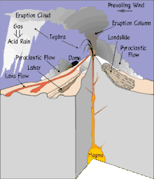
Lava flows
There are different forms of effusive lava that can provide different hazards. Pahoehoe lava is smooth and ropy while Aa lava is blocky and hard. Lava flows normally follow the topography, sinking into depressions and valleys and flowing down the volcano. Lava flows will bury roads farmlands and other forms of personal property.[1] This lava could destroy homes, cars, and lives standing in the way.[2] Lava flows are dangerous, however, they are slow moving and this gives people time to respond and evacuate out of immediate areas. People can mitigate this hazard by not moving to valleys or depressed areas around a volcano.[3]
Pyroclastic materials (tephra) and flow
Tephra is a generalized word for the various bits of debris that are launched out of a volcano during an eruption, regardless of their size.[4] Pyroclastic materials are generally categorized according to size: dust measures at <1/8 mm, ash is 1/8–2 mm, cinders are 2–64 mm, and bombs and blocks are both >64 mm.[5] There are different hazards associated with the different kinds of pyroclastic materials. Dust and ash could coat cars and homes, rendering the car unable to drive with dust accumulation in the engine. They could also layer on homes and add weight to roofs causing the house to collapse. Also, ash and dust inhaled could cause long-term respiratory issues in people inhaling the particles.[6] Cinders are flaming pieces of ejected volcanic material which could set fire to homes and wooded areas. Bombs and blocks run the risk of hitting various objects and people within range of the volcano. Projectiles can be thrown thousands of feet in the air and can be found several miles away from the initial eruption point.[7]
A pyroclastic flow is a fast-moving (up to 700 km/hr) extremely hot (~1000 °C) mass of air and tephra that charges down the sides of a volcano during an explosive eruption.
Mudflows, floods, debris flows and avalanches
When pyroclastic materials mix with water from a nearby stream or river, they can turn the watercourse into a fast moving mudflows. These are called lahars;[8] when the lahar contains large material such as blocks of rock and trees, it is a volcanic debris flow.[9] Lahars can form directly from a pyroclastic material flow flowing into a river, or could possibly form after the main eruption. The latter is referred to as secondary lahars and form when rain wets the ash and debris already on a landscape and stick together rolling along the topography. It's estimated that it can only take 30% water to initiate ash into a lahar.[10] The thicker and/or more fast-moving a lahar, the more potential to destroy things in its path, thus making it more dangerous than a slower and/or more diluted lahar. Lahars and mudflows can damage buildings, wildlife and cars and can prove difficult to escape once caught in them. The lahars can coat objects, wash objects away and can knock objects down by their force. Lahars, debris flows and mudflows that travel into a river or stream run the potential for crowding the waterway, forcing the water to flow outward and causing a flood. The volcanic matter could also pollute the water, making it unsafe to drink.
The debris that is ejected from the volcano adds to the sides of the slope with each eruption, making the sides steeper each time. Eventually the slope gets so steep that it fails and an avalanche ensues.[11] These avalanches carry material and debris for very long distances at very short intervals. This makes a warning system nearly immposible because the slope failure could occur at any time. The avalanche will destroy anything in its path including personal property, houses, buildings, vehicles and possibly even wildlife. If the impact of the materials in the avalanche doesn't destroy the person or object at first contact, there could be damage resulting from the weight of prolonged material on the objects.[12]
Earthquakes related to volcanism
Earthquakes can occur due to volcanic activity. These earthquakes could produce topographical deformation and/or destruction of buildings, homes, cars, etc. There are two different types of these earthquakes: volcano tectonic earthquakes and long period earthquakes. "Earthquakes produced by stress changes in solid rock due to the injection or withdrawal of magma (molton rock) are called volcano tectonic earthquakes".[13] These are hazardous due to the possibility of ground cracks or slope failures, therefore destroying everything in its path.[13] Long period earthquakes, which happen when magma is suddenly forced into the surrounding rocks, are generally seen as a precursor to the actual eruption.[13]
Monitoring and mitigation
According to John Ewert and Ed Miller in a 1995 publication, "a great majority of the world's potentially active volcanoes are unmonitored". Of the historically active volcanoes in the world, less than one fourth are monitored. Only twenty-four volcanoes in the entire world are thoroughly monitored for activity. They also state that "seventy-five percent of the largest explosive eruptions since 1800 occurred at volcanoes that had no previous historical eruptions".[14]
By monitoring the seismic and geological activity, the USGS can warn people ahead of time about impending danger. These volcanologists measure the size of an eruption in two ways: the eruption magnitude (by the volume or mass of magma erupted) and eruption intensity (by the rate of magma erupted).[15] There are also various forms of satellites and imagery, such as satellite InSAR imagery, that monnitor the activity that isn't exposed to the naked eye.[16]
However, the situation has somewhat changed with the International Decade for Natural Disaster Reduction [17] and the Yokohama strategy since 1994.[18] The Global Assessment of Risk (GAR) report is a biennial review and analysis of natural hazards published by the United Nations Office for Disaster Risk Reduction (UNISDR). The report implements the UN Hyogo Framework for Action. [19]
Zadeh et al. (2014) provide an overview on Risks and Societal Implications of extreme natural hazards and an assessment of the global risk of volcanos and contains an appeal to found a worldwide volcanological organization comparable to the WMO .[20] The EU has recently started major research programs dealing with risk assessment, compare:
- NOVAC - Network for Observation of Volcanic and Atmospheric Change,[21][22]
- MULTIMO Multidisciplinary Monitoring, Modelling and Forecasting of Volcanic Hazard, Explosive Eruption Risk and Decision Support for EU Populations Threatened by Volcanoes,
- ERUPT Processes and Timescale of Magma Evolution in Volcanic Systems
- E-RUPTIONS A Satellite Telecommunication and Internet-Based Seismic Monitoring System for Volcanic Eruption Forecasting and Risk Management
- EXPLORIS Explosive Eruption Risk and Decision Support for EU Populations Threatened by Volcanoes [23]
The British Geological Survey has various ongoing volcanology programs.[24]
References
- ↑ Kusky, 24
- ↑ Rosi, 63
- ↑ Ernst, et. al, 6693
- ↑ USGS, Volcanic Hazards: Tephra, including volcanic ash
- ↑ Decker, 122
- ↑ Volcanic hazards, Oregon Department of Geology and Mineral Industries
- ↑ Kusky, 27
- ↑ Olsen, et. al 48
- ↑ Decker, 144
- ↑ Kusky 30
- ↑ Living With Volcanoes (USGS) 18
- ↑ Lockwood, 42
- 1 2 3 Volcanic Earthquakes
- ↑ "The USGS/OFDA Volcano Disaster Assistance Program". United States Geological Survey. March 21, 2001. Retrieved February 25, 2010.
- ↑ Volcanic Hazards of Yellowstone National Park
- ↑ Zhong, et. al 55
- ↑ 1994/31. International Decade for Natural Disaster Reduction
- ↑ Compare the International Association of Volcanology and Chemistry of the Earth's Interior contribution to the International decade
- ↑ The Global Assessment of Risk (GAR) report
- ↑ "Extreme Natural Hazards, Disaster Risks and Societal Implications, Zadeh et al Cambridge University Press, 17.04.2014".
- ↑ NOVAC homepage
- ↑ Network for Observation of Volcanic and Atmospheric Change (NOVAC)-A global network for volcanic gas monitoring: Network layout and instrument description
- ↑ EU programs on volcanology
- ↑ Summary of recent volcanology projects Sue Loughlin, British Geological Survey
Bibliography
- Cutter, Susan, (1993) Living with Risk: The Geography of Technological Hazards, Edward Arnold Publishing ISBN 0-340-52987-3
- Decker, Robert and Barbara Decker (2006) Volcanoes, (4th ed.) W.H. Freeman and Company Publishing ISBN 0-7167-8929-9
- Ernst, G. G., M. Kervyn and R. M. Teeuw, Advances in the remote sensing of volcanic activity and hazards, with special consideration to applications in developing countries, International Journal of Remote Sensing; Nov 2008, Vol. 29 Issue 22
- Fauziati, S. and K. Watanabe, Ontology of Volcano System and Volcanic Hazards Assessment, International Journal of Geoinformatics; Dec 2010, Vol. 6 Issue 4 Article
- Kusky, Timothy (2008) Volcanoes: eruptions and other volcanic hazards, Infobase Publishing ISBN 0-8160-6463-6
- Lockwood, John P. (2010) Volcanoes : global perspectives, Wiley-Blackwell Publishing ISBN 978-1-4051-6250-0
- Martin, Thomas R., Alfred P. Wehner and John Butler, Evaluation of Physical Health Effects Due to Volcanic Hazards: The Use of Experimental Systems to Estimate the Pulmonary Toxicity of Volcanic Ash, American Journal of Public Health; Mar 86 Supplement, Vol. 76 Issue 3
- Olsen, Khris B. and Jonathan S. Fruchter, Identification of the Physical and Chemical Characteristics of Volcanic Hazards, American Journal of Public Health; Mar86 Supplement, Vol. 76 Issue 3
- Rosi, Mauro, Paolo Papale, Luca Lupe and Marco Stoppato, (2003) Volcanoes, Firefly Books Ltd Publishing ISBN 1-55297-683-1
- USGS, Living With Volcanoes The Geological Survey's Volcano Hazards Program. (1991). US Geological Survey Circular 1073.
- Zhong Lu, Jixian Zhang, Yonghong Zhang and Daniel Dzurisin, Monitoring and characterizing natural hazards with satellite InSAR imagery, Journal Annals of GIS; Mar 2010, Vol. 16 Issue 1