Vlastislav (Hazlov)
| Vlastislav | |
| Village | |
 | |
| Official name: Táborská | |
| Country | Czech Republic |
|---|---|
| Region | Karlovy Vary |
| District | Cheb |
| Municipality | Hazlov |
| Elevation | 535 m (1,755 ft) |
| Coordinates | 50°8′28″N 12°15′51″E / 50.14111°N 12.26417°ECoordinates: 50°8′28″N 12°15′51″E / 50.14111°N 12.26417°E |
| Area | 2.94 km2 (1.1 sq mi) |
| Population | 13 (2001) |
| Density | 4/km2 (10/sq mi) |
| First mentioned | 1332 |
| Timezone | CET (UTC+1) |
| - summer (DST) | CEST (UTC+2) |
| Postal code | 35132 |
| Wikimedia Commons: Táborská (Hazlov) | |
Vlastislav, formerly Táborská (German: Seichenreuth) is a village in Karlovy Vary Region, Czech Republic. It is one of the six municipality districts of Hazlov. In 2001 the village had a population of 13.
Geography
Vlastislav lies 3 kilometres southwest from Hazlov, about 535 meters above sea level. It is surrounded by forests. It neighbour with Polná to the northwest, with Libá to the southwest, with Ostroh to the southeast, with Poustka to the east and with Hazlov to the northeast.
History
Vlastislav was first mentioned in 1322.[1] Oldest names of the village are; Sewkenrewt (1322), Seukenreuth, Schewkenrewt, Seikeinreit and Seiscenreit.[1]
From 1869 to 1910, village was a part of municipality of Ostroh. In 1921, Vlastislav created an own municipality. Later was joined to Polná, and in 1961 was finally joined to Hazlov. In 2016 the village was renamed from Táborská to Vlastislav.
Gallery
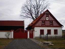
.JPG) One of local frame-houses.
One of local frame-houses..JPG) Old farmhouse, rebuilt to private clinic.
Old farmhouse, rebuilt to private clinic.
References
Sources
- SCHREINER, Lorenz: Heimatkreis Eger, Egereg Landtag e.V. (1997)
- STURM, Heribert: Ortslexikon der Böhmischen Länder, Oldenbourg (1995)