Vitruvius (crater)
 | |
| Coordinates | 17°36′N 31°18′E / 17.6°N 31.3°ECoordinates: 17°36′N 31°18′E / 17.6°N 31.3°E |
|---|---|
| Diameter | 30 km |
| Depth | 1.5 km |
| Colongitude | 329° at sunrise |
| Eponym | Marcus P. Vitruvius |

.jpg)
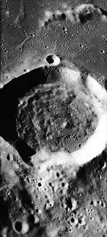
Vitruvius is a small lunar impact crater that lies on the northern edge of the Mare Tranquillitatis. Less than 90 km north is the crater Littrow, about 45 km northwest is Fabbroni, about 48 km east is Gardner and 53 km southwest is Beketov. About 35 km north-northwest is the elongated Mons Vitruvius mountain, and beyond is the valley where the Apollo 17 mission landed. Also south is Dorsa Barlow (Barlow Hills), further southeast is Mons Esam (Esam Mountains).
Its diameter is 30 km long and is 1,880 meters deep. The area is between 675 and 700 km² and the perimeter is less than 100 km.
The rim of Vitruvius is somewhat circular, but the sides are uneven to the north and east. The rim is highest to the northwest. The interior floor is uneven, with some low rises in the southwest. A small crater is attached to southern outer rim. The surroundings grow more rugged to the north of the crater.
Names
The crater is named after the great Roman engineer and architect Marcus P. Vitruvius. Like many of the craters on the Moon's near side, Vitruvius was named by Giovanni Riccioli, whose 1651 nomenclature system has become standardized.[1] Earlier lunar cartographers had given the feature different names: Michael van Langren's 1645 map calls it "Cocci"[2]
Also before 1645, south of what is now Vitruvius was a promontory named "Promontorium Sancti Alberti", named for Saint Albert.[3][4] After 1651, the promontory would not have a name. The area that was a promontory is considered to be known today as Dorsa Barlow, a wrinkle ridge.
Satellite craters
By convention,these features are identified on lunar maps by placing the letter on the side of the crater midpoint that is closest to Vitruvius.[5]
| Vitruvius | Latitude | Longitude | Diameter |
|---|---|---|---|
| B | 16.4° N | 33.0° E | 18 km |
| G | 13.9° N | 34.6° E | 6 km |
| H | 16.4° N | 33.9° E | 22 km |
| L | 19.0° N | 30.7° E | 6 km |
| M | 16.1° N | 31.5° E | 5 km |
| T | 17.1° N | 33.2° E | 15 km |
The following craters have been renamed by the IAU.
- Vitruvius A — See Gardner (crater).
- Vitruvius E — See Fabbroni (crater).
View of the Earth
Being located at the 17th parallel north area, the view of the Earth is seen at the lunar sky all year round at around 73 degrees facing south and at about 31 degrees towards the west from the top.
See also
Notes
- ↑ Ewen A. Whitaker, Mapping and Naming the Moon (Cambridge University Press, 1999), p.211.
- ↑ Ewen A. Whitaker, Mapping and Naming the Moon (Cambridge University Press, 1999), p. 197.
- ↑ There are several saints called Albert. The likeliest one may be Saint Albert the Great.
- ↑ Langren, Michael van (1645). "Map of the Moon in the book Plenilunii lumina Austriaca Philippica".
- ↑ Bussey, B.; Spudis, P. (2004). The Clementine Atlas of the Moon. New York: Cambridge University Press. ISBN 0-521-81528-2.
References
- Andersson, L. E.; Whitaker, E. A. (1982). NASA Catalogue of Lunar Nomenclature. NASA RP-1097.
- Blue, Jennifer (July 25, 2007). "Gazetteer of Planetary Nomenclature". USGS. Retrieved 2007-08-05.
- Cocks, Elijah E.; Cocks, Josiah C. (1995). Who's Who on the Moon: A Biographical Dictionary of Lunar Nomenclature. Tudor Publishers. ISBN 978-0-936389-27-1.
- McDowell, Jonathan (July 15, 2007). "Lunar Nomenclature". Jonathan's Space Report. Retrieved 2007-10-24.
- Menzel; Minnaert, M.; Levin, B.; Dollfus, A.; Bell, B. (1971). "Report on Lunar Nomenclature by the Working Group of Commission 17 of the IAU". Space Science Reviews. 12 (2): 136–186. Bibcode:1971SSRv...12..136M. doi:10.1007/BF00171763.
- Moore, Patrick (2001). On the Moon. Sterling Publishing Co. ISBN 978-0-304-35469-6.
- Price, Fred W. (1988). The Moon Observer's Handbook. Cambridge University Press. ISBN 978-0-521-33500-3.
- Rükl, Antonín (1990). Atlas of the Moon. Kalmbach Books. ISBN 978-0-913135-17-4.
- Webb, Rev. T. W. (1962). Celestial Objects for Common Telescopes (6th revised ed.). Dover. ISBN 978-0-486-20917-3.
- Whitaker, Ewen A. (1999). Mapping and Naming the Moon. Cambridge University Press. ISBN 978-0-521-62248-6.
- Wlasuk, Peter T. (2000). Observing the Moon. Springer. ISBN 978-1-85233-193-1.
External links
| Wikimedia Commons has media related to Vitruvius (crater). |
Related articles
- Wood, Chuck (August 16, 2004). "Megadome". Lunar Photo of the Day. Retrieved September 27, 2017. - also featuring the surrounding craters including Vitruvius
- "A New Fault". Lunar Photo of the Day. October 22, 2007. Archived from the original on August 1, 2017.