Virginia State Route 38
| ||||
|---|---|---|---|---|
 | ||||
| Route information | ||||
| Maintained by VDOT | ||||
| Length | 7.03 mi[1] (11.31 km) | |||
| Existed | 1933–present | |||
| Tourist routes |
| |||
| Major junctions | ||||
| West end |
| |||
| East end |
| |||
| Location | ||||
| Counties | Amelia | |||
| Highway system | ||||
| ||||

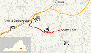
State Route 38 (SR 38) is a primary state highway in the U.S. state of Virginia. Known for most of its length as Five Forks Road, the state highway runs 7.03 miles (11.31 km) from U.S. Route 360 Business (US 360 Business) in Amelia Court House east to SR 153 at Scotts Fork.
Route description
_at_Virginia_Street_(Virginia_State_Secondary_Route_1009)_in_Amelia_Courthouse%2C_Amelia_County%2C_Virginia.jpg)
SR 38 begins at an intersection with US 360 Business (Goodes Bridge Road) in Amelia Court House, where the highway makes a series of right-angle turns. The state highway heads south on Virginia Avenue, turns east onto Court Street, turns south on Washington Street to follow the east side of the courthouse property, turns east onto Church Street, and turns south onto Five Forks Road. Between Amelia Academy and Amelia County High School at its junction with SR 614, which heads west as Otterburn Road and south as Dennisville Road, SR 38 turns east with Five Forks Road. The state highway heads east to its eastern terminus at SR 153 (Military Road) at Scotts Fork. The roadway continues east as SR 602 (Bevils Bridge Road), which continues east into Chesterfield County toward Petersburg.[1][2]
History
All of SR 38, plus extensions east to Sutherland and northwest to Tobaccoville, was State Route 406 before the 1933 renumbering. At that time, State Route 38 was assigned to the piece from Amelia Court House east to Sutherland; Amelia Court House to Tobaccoville became part of State Route 49. In the 1940 renumbering, SR 49 was greatly truncated, and SR 38 was extended northwest over former SR 49 to Tobaccoville.[3] SR 38 east of the south junction with SR 153, a road of "little primary significance", was transferred to the secondary system in 1951 as SR 708; the rest of SR 38 east of Amelia Court House became an extension of SR 153.[4] However, later that year, SR 38 returned to the piece from Amelia Court House to the SR 153/SR 708 junction, and SR 153 was rerouted to go north from Scotts Fork.[5] The overlap with SR 153 has since been removed. The piece of SR 38 from Tobaccoville via Morven to Amelia Court House became SR 681 in 1954.[6]
Major intersections
The entire route is in Amelia County.
| Location | mi[1] | km | Destinations | Notes | |
|---|---|---|---|---|---|
| Amelia Court House | 0.00 | 0.00 | |||
| Scotts Fork | 7.03 | 11.31 | |||
| 1.000 mi = 1.609 km; 1.000 km = 0.621 mi | |||||
References
- 1 2 3 "2009 Traffic Data". Virginia Department of Transportation. 2009. Retrieved 2011-08-19.
- Amelia County (PDF)
- ↑ Google (2011-08-19). "Virginia State Route 38" (Map). Google Maps. Google. Retrieved 2011-08-19.
- ↑ State Highway Commission of Virginia (October 10, 1940). Minutes of Meeting (PDF) (Report). Richmond, VA: Commonwealth of Virginia. , page 10
- ↑ State Highway Commission of Virginia (April 9–11, 1951). Minutes of Meeting (PDF) (Report). Roanoke and Richmond, VA: Commonwealth of Virginia. , page 21
- ↑ State Highway Commission of Virginia (August 14, 1951). Minutes of Meeting (PDF) (Report). Richmond, VA: Commonwealth of Virginia. , page 34
- ↑ State Highway Commission of Virginia (May 12–14, 1954). Minutes of Meeting (PDF) (Report). Roanoke and Richmond, VA: Commonwealth of Virginia. , page 8
External links
| Wikimedia Commons has media related to Virginia State Route 38. |
Route map:
| < SR 131 | Spurs of SR 13 1923-1928 |
SR 133 > |
| < SR 405 | District 4 State Routes 1928–1933 |
SR 407 > |