Virginia State Route 108
| ||||
|---|---|---|---|---|
| Figsboro Road | ||||
 | ||||
| Route information | ||||
| Maintained by VDOT | ||||
| Length | 4.24 mi[1] (6.82 km) | |||
| Existed | 1933–present | |||
| Major junctions | ||||
| South end |
| |||
| North end |
| |||
| Location | ||||
| Counties | Henry | |||
| Highway system | ||||
| ||||

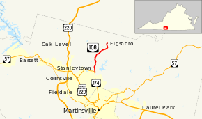
State Route 108 (SR 108) is a primary state highway in the U.S. state of Virginia. Known as Figsboro Road, the state highway runs 4.24 miles (6.82 km) from SR 174 near Collinsville north to SR 657 and SR 890 at Figsboro.
Route description
_at_Virginia_State_Route_174_(Kings_Mountain_Road)_just_northeast_of_Collinsville_in_Henry_County%2C_Virginia.jpg)
View north at the south end of SR 108 at SR 174 near Collinsville
SR 108 begins at an acute intersection with SR 174 (Kings Mountain Road) east of Collinsville and north of Martinsville. The state highway heads north through northern Henry County. SR 108 reaches its northern terminus at its intersection with SR 657 (Old Quarry Road) at Figsboro. Figsboro Road continues north as SR 890 toward SR 40 at Penhook in southern Franklin County.[1][2]
Major intersections
The entire route is in Henry County.
| Location | mi[1] | km | Destinations | Notes | |
|---|---|---|---|---|---|
| | 0.00 | 0.00 | Southern terminus | ||
| Figsboro | 4.24 | 6.82 | Northern terminus | ||
| 1.000 mi = 1.609 km; 1.000 km = 0.621 mi | |||||
References
- 1 2 3 "2010 Traffic Data". Virginia Department of Transportation. 2010. Retrieved 2011-10-25.
- ↑ Google (2011-10-25). "Virginia State Route 108" (Map). Google Maps. Google. Retrieved 2011-10-25.
External links
| Wikimedia Commons has media related to Virginia State Route 108. |
Route map:
| < SR 201 | District 2 State Routes 1928–1933 |
SR 203 > |
This article is issued from
Wikipedia.
The text is licensed under Creative Commons - Attribution - Sharealike.
Additional terms may apply for the media files.