Vinton Township, Vinton County, Ohio
| Vinton Township, Vinton County, Ohio | |
|---|---|
| Township | |
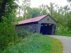 Eakin Mill Covered Bridge, a historic site in the township | |
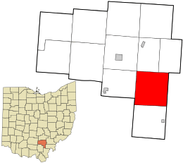 Location in Vinton County and the state of Ohio. | |
| Coordinates: 39°9′36″N 82°22′27″W / 39.16000°N 82.37417°WCoordinates: 39°9′36″N 82°22′27″W / 39.16000°N 82.37417°W | |
| Country | United States |
| State | Ohio |
| County | Vinton |
| Area | |
| • Total | 36.9 sq mi (95.6 km2) |
| • Land | 36.9 sq mi (95.6 km2) |
| • Water | 0.0 sq mi (0.0 km2) |
| Elevation[1] | 853 ft (260 m) |
| Population (2010) | |
| • Total | 548 |
| • Density | 14.9/sq mi (5.7/km2) |
| Time zone | UTC-5 (Eastern (EST)) |
| • Summer (DST) | UTC-4 (EDT) |
| FIPS code | 39-80192[2] |
| GNIS feature ID | 1087109[1] |
Vinton Township is one of the twelve townships of Vinton County, Ohio, United States. The 2010 census found 548 people in the township.
Geography
Located in the southern part of the county, it borders the following townships:
- Madison Township: north
- Knox Township: northeast
- Columbia Township, Meigs County: east
- Salem Township, Meigs County: southeast corner
- Wilkesville Township: south
- Milton Township, Jackson County: southwest
- Clinton Township: west
- Elk Township: northwest corner
No municipalities are located in Vinton Township, although the unincorporated community of Oreton lies in the township's west.
Name and history
Like the county in which it is contained, Vinton Township was named for Samuel Finley Vinton.[3]
It is the only Vinton Township statewide.[4]
Government
The township is governed by a three-member board of trustees, who are elected in November of odd-numbered years to a four-year term beginning on the following January 1. Two are elected in the year after the presidential election and one is elected in the year before it. There is also an elected township fiscal officer,[5] who serves a four-year term beginning on April 1 of the year after the election, which is held in November of the year before the presidential election. Vacancies in the fiscal officership or on the board of trustees are filled by the remaining trustees.
References
- 1 2 "US Board on Geographic Names". United States Geological Survey. 2007-10-25. Retrieved 2008-01-31.
- ↑ "American FactFinder". United States Census Bureau. Retrieved 2008-01-31.
- ↑ History of Hocking Valley, Ohio. Inter-State Publishing Co. 1883. p. 1350.
- ↑ "Detailed map of Ohio" (PDF). United States Census Bureau. 2000. Retrieved 2007-02-16.
- ↑ §503.24, §505.01, and §507.01 of the Ohio Revised Code. Accessed 4/30/2009.
External links
Municipalities and communities of Vinton County, Ohio, United States | ||
|---|---|---|
| Villages |  | |
| Townships | ||
| Unincorporated communities | ||
| Ghost towns | ||