Villard Point
Location of Byers Peninsula, Livingston Island in the South Shetland Islands.

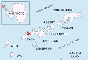
Topographic map of Livingston Island, Greenwich, Robert, Snow and Smith Islands.
Villard Point is a point projecting 500 m into Barclay Bay from Robbery Beaches on Byers Peninsula, Livingston Island in the South Shetland Islands, Antarctica and forming the east side of the entrance to Baba Tonka Cove and the west side of the entrance to Kukuzel Cove.
The point was named in 1971 by the Chilean Antarctic Expedition following geological work in the area, probably after a member of the expedition.
Location
The point is located at 62°36′43.9″S 61°03′25.9″W / 62.612194°S 61.057194°W which is 1.19 km east-southeast of Varadero Point and 1.16 km west-northwest of Lair Point (British mapping in 1968, Chilean mapping in 1971, detailed Spanish mapping in 1992, and Bulgarian mapping in 2005 and 2009).
Maps
- Península Byers, Isla Livingston. Mapa topográfico a escala 1:25000. Madrid: Servicio Geográfico del Ejército, 1992.
- L.L. Ivanov et al. Antarctica: Livingston Island and Greenwich Island, South Shetland Islands. Scale 1:100000 topographic map. Sofia: Antarctic Place-names Commission of Bulgaria, 2005.
- L.L. Ivanov. Antarctica: Livingston Island and Greenwich, Robert, Snow and Smith Islands. Scale 1:120000 topographic map. Troyan: Manfred Wörner Foundation, 2009. ISBN 978-954-92032-6-4
References
This article is issued from
Wikipedia.
The text is licensed under Creative Commons - Attribution - Sharealike.
Additional terms may apply for the media files.