Barclay Bay
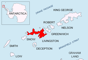
Location of Livingston Island in the South Shetland Islands.

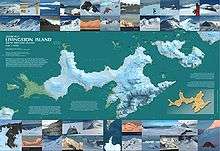
Topographic map of Livingston Island.
Barclay Bay (62°33′S 60°58′W / 62.550°S 60.967°WCoordinates: 62°33′S 60°58′W / 62.550°S 60.967°W) is a bay lying between Cape Shirreff and Essex Point on the north side of Livingston Island, in the South Shetland Islands. Its head is fed by Etar Snowfield. The name appears on an 1825 chart of the British sealing expedition under James Weddell, and is now established in international usage.
Maps
- South Shetland Islands. Scale 1:200000 topographic map No. 5657. DOS 610 – W 62 60. Tolworth, UK, 1968.
- Islas Livingston y Decepción. Mapa topográfico a escala 1:100000. Madrid: Servicio Geográfico del Ejército, 1991.
- L.L. Ivanov et al. . Scale 1:100000 topographic map. Sofia: Antarctic Place-names Commission of Bulgaria, 2005.
 Antarctica: Livingston Island and Greenwich Island, South Shetland Islands
 - L.L. Ivanov. Antarctica: Livingston Island and Greenwich, Robert, Snow and Smith Islands. Scale 1:120000 topographic map. Troyan: Manfred Wörner Foundation, 2009. ISBN 978-954-92032-6-4
- Antarctic Digital Database (ADD). Scale 1:250000 topographic map of Antarctica. Scientific Committee on Antarctic Research (SCAR). Since 1993, regularly upgraded and updated.
- L.L. Ivanov. Antarctica: Livingston Island and Smith Island. Scale 1:100000 topographic map. Manfred Wörner Foundation, 2017. ISBN 978-619-90008-3-0
References
External links

This article is issued from
Wikipedia.
The text is licensed under Creative Commons - Attribution - Sharealike.
Additional terms may apply for the media files.