Tarfaya
| Tarfaya طرفاية ⵟⴰⵔⴼⴰⵢⴰ | |
|---|---|
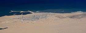 Tarfaya skyline | |
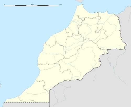 Tarfaya Location in Morocco, as shown at bottom left. | |
| Coordinates: 27°56′22″N 12°55′34″W / 27.93944°N 12.92611°W | |
| Country |
|
| Region | Laâyoune-Sakia El Hamra |
| Province | Tarfaya Province |
| Population (2004) | |
| • Total | 5,615 |
| Time zone | UTC+0 (WET) |
| • Summer (DST) | UTC+1 (WEST) |
| Website | http://tarfaya.info |
.jpg)
Tarfaya (Arabic: طرفاية - Ṭarfāya; Berber languages: ⵟⴰⵔⴼⴰⵢⴰ) is a town, previously also known as Villa Bens during the Spanish period, located in the Tarfaya Province of the Laâyoune-Sakia El Hamra region of southwestern Morocco.[1] It is a port town on the Atlantic coast, close to Cape Juby, which shares its name with the southern region of Morocco, and is located 890 km southwest of Rabat. According to the 2004 census, Tarfaya has a population of 5,615, the smallest of the four municipalities of the region, but it is the only one outside of the disputed Western Sahara.[2]
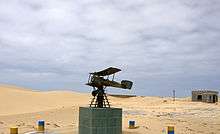
In the 1920s, the French commercial air carrier Aéropostale constructed an airfield here. A small monument now stands at that site to honour the air carrier, its pilots in general and the French aviator and author Antoine de Saint-Exupéry in particular. He served as station manager here during his career as an airmail pilot.
History
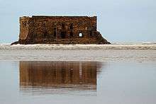
Tarfaya was occupied by the British in 1882, when they built a trading post called Casa del Mar.[3] The building is currently in a state of complete disrepair. The Sahrawi tribes then solicited the intervention of Sultan Hassan I who negotiated the withdrawal of the British in 1895 by Treaty of Cape Juby.[4] In 1912 the territory of Tarfaya, then named Cape Juby, was occupied by Spain as part of the Spanish Sahara. The greater Cape Juby region plus Tarfaya were unified with Morocco in 1958, at the end of the Ifni War. For a while, in 2007, a ferry service, operated by a Spanish, Canary Islands-based company: 'Naviera Armas', existed between Tarfaya and the island of Fuerteventura.[5] In December 2014 the Tarfaya Wind Farm, largest wind farm in Africa, was commissioned.[6]
Aéropostale
Tarfaya's association with Aéropostale began in 1927. The airmail carrier, based in Toulouse, France, was founded by French industrialist Pierre-Georges Latécoère, who envisioned an air route connecting France to its French colonies in Africa. Latécoère firmly believed in the future of aviation as a means of commercial transportation and communication between people.
The nearby Cape Juby airfield was an important refueling and stopover station for Aéropostale. Author-aviator Antoine de Saint-Exupéry was named its station manager in 1927. There he remained for 18 months, on occasion negotiating with the rebellious Moorish tribes to release his imprisoned pilots, as he wrote in his first novel, Southern Mail.
On 28 September 2004 a museum opened in honour of the memory of Aéropostale, Saint-Exupéry and its pilots, supported notably by the city of Toulouse and French aircraft maker Airbus. The museum was inaugurated by renowned aviation journalist Bernard Chabbert, whose father was also part of Aéropostale's history.
Air services
The town maintains the Tarfaya Airport with the IATA code TFY.
Ferry
From December 2007 to April 2008, when the 'Assalama', a ship from 'Naviera Armas' ran aground, a ferry connecting Tarfaya and Fuerteventura, Canary Islands, ran. Plans are reported to exist to put the line back into operation.[7]
Climate
Tarfaya has a mild desert climate (BWn).
| Climate data for Tarfaya | |||||||||||||
|---|---|---|---|---|---|---|---|---|---|---|---|---|---|
| Month | Jan | Feb | Mar | Apr | May | Jun | Jul | Aug | Sep | Oct | Nov | Dec | Year |
| Average high °C (°F) | 19 (66) |
19 (66) |
20 (68) |
21 (70) |
21 (70) |
22 (72) |
22 (72) |
23 (73) |
23 (73) |
23 (73) |
22 (72) |
20 (68) |
21 (70) |
| Daily mean °C (°F) | 16 (61) |
16 (61) |
17 (63) |
18 (64) |
18 (64) |
19 (66) |
20 (68) |
20 (68) |
20 (68) |
20 (68) |
19 (66) |
16 (61) |
18 (64) |
| Average low °C (°F) | 13 (55) |
13 (55) |
14 (57) |
15 (59) |
16 (61) |
17 (63) |
18 (64) |
18 (64) |
18 (64) |
17 (63) |
16 (61) |
13 (55) |
16 (61) |
| Average precipitation cm (inches) | 0 (0) |
0 (0) |
0 (0) |
0 (0) |
0 (0) |
0 (0) |
0 (0) |
0 (0) |
0 (0) |
0 (0) |
1 (0.4) |
0 (0) |
4 (1.6) |
| Source: Weatherbase[8] | |||||||||||||
References
| Wikimedia Commons has media related to Tarfaya. |
- Citations
- ↑ "World Gazetteer website". Archived from the original on 2012-05-13.
- ↑ Maaroufi, Youssef. "Recensement général de la population et de l'habitat 2004".
- ↑ (in French), acquiring their trading office. Petite histoire de Tarfaya Archived 2012-04-02 at the Wayback Machine.
- ↑ Hertslet, E. (2013). The Map of Africa by Treaty. Routledge. p. 970. ISBN 978-1-136-01918-0.
- ↑ https://lanzarote-canarias.com/ferry_canarias_marruecos/
- ↑ Staff, Utilities ME. "GDF SUEZ launches $560mn Moroccan wind farm - utilities-me.com". www.utilities-me.com.
- ↑ diariodefuerteventura.es. "Diario de Fuerteventura". diariodefuerteventura.es.
- ↑ "Weatherbase: Historical Weather for Tarfaya".
- Bibliography
- Didier Daurat, Saint-Exupéry tel que je l'ai connu, France: Édition Dynamo, 1954.
Coordinates: 27°56′22″N 12°55′34″W / 27.93944°N 12.92611°W
Capital: Laâyoune | ||
| Provinces | 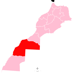 | |
| Municipalities | ||