Viking Bergen Island
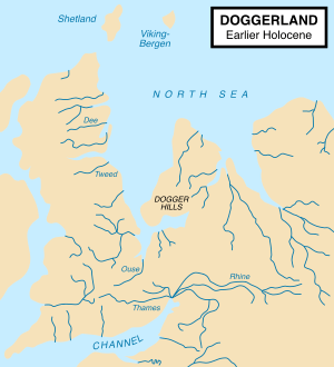
Paleogeographic reconstruction of the North Sea approximately around 7000 BC during the young Holocene and after the end of the last glacial period. Viking–Bergen can be seen near the top in the centre.
Viking–Bergen is a hypothetical former island between modern Scotland and Norway, at the boundary of the North Sea, and Norwegian Sea.[1] The area is now known as the "Viking–Bergen banks" (combining the Viking and Bergen ocean banks).
During the Bølling–Allerød Period, known in Britain as the Windermere interstadial, the northern coast of Doggerland began to recede as global sea levels rose. There may have been a Shetland island marking the northern end of a bay north of the Dogger Hills, and the Viking–Bergen island would have been between the bay and the Norwegian Trench.
See also
References
This article is issued from
Wikipedia.
The text is licensed under Creative Commons - Attribution - Sharealike.
Additional terms may apply for the media files.