Antonio Rivera Rodríguez Airport
| Antonio Rivera Rodríguez Airport | |||||||||||
|---|---|---|---|---|---|---|---|---|---|---|---|
 | |||||||||||
| Summary | |||||||||||
| Airport type | Public | ||||||||||
| Owner | Puerto Rico Ports Authority | ||||||||||
| Serves | Isla De Vieques, Puerto Rico | ||||||||||
| Hub for | Vieques Air Link | ||||||||||
| Elevation AMSL | 49 ft / 15 m | ||||||||||
| Coordinates | 18°08′05″N 65°29′38″W / 18.13472°N 65.49389°WCoordinates: 18°08′05″N 65°29′38″W / 18.13472°N 65.49389°W | ||||||||||
| Map | |||||||||||
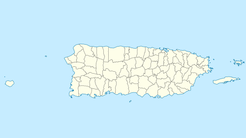 VQS Location of airport in Puerto Rico | |||||||||||
| Runways | |||||||||||
| |||||||||||
Antonio Rivera Rodríguez Airport (IATA: VQS, ICAO: TJVQ, FAA LID: VQS) is a public airport on the island of Vieques in Puerto Rico. Because a large amount of Vieques's yearly revenue comes from the tourism industry, this airport plays an important part in the Vieques economy. For decades, the airport has been the hub of Vieques Air Link, and also a destination for a number of small airlines.
It is included in the National Plan of Integrated Airport Systems for 2011–2015, which categorized it as a primary commercial service airport (more than 10,000 enplanements per year).[4]
History
When anti-military demonstrators started flocking into Vieques in 1999, Vieques Airport saw a considerable increase to its normal yearly average of passengers. In addition, many celebrities who travelled from all over Puerto Rico and the rest of Latin America to join the protesters arrived at Vieques through this airport. When Carla Tricoli, a Vieques native, won the 2002 Miss Puerto Rico contest, her first flight as a beauty queen landed at Vieques Airport.
The airport does not accept jet aircraft, but several international flights operate from it. Most of the commercial aviation operations are domestic flights such as to Ceiba, to Isla Grande Airport in San Juan, and to Luis Muñoz Marín International Airport in Carolina, a suburb of San Juan. Air ambulance flights to San Juan are also available.
Early in 2005, plans were announced to expand the airport's runway, so that the airport could accept flights by smaller jets. This would be done in preparation for American Eagle to start operations to the airport. The airline was expected to start flights to Vieques from San Juan's Luis Muñoz Marin International Airport in early 2010, but the airline decided not to begin service.
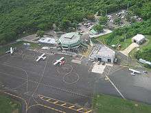
Facilities
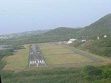
Antonio Rivera Rodríguez Airport covers an area of 124 acres (50 ha) at an elevation of 49 feet (15 m) above mean sea level. It has one runway designated 9/27 with an asphalt surface measuring 4,300 by 75 feet (1,311 by 23 m).[1]
The Roosevelt Roads TACAN (Ident: NRR) is located 10.4 nautical miles (12.0 mi; 19.3 km) northwest of the airport. The St Thomas VOR-DME (Ident: STT) is located 29.9 nautical miles (34.4 mi; 55.4 km) east-northeast of the airport. The San Juan VORTAC (Ident: SJU) is located 33.9 nautical miles (39.0 mi; 62.8 km) west-northwest of the airport.[5][6][7]
Airlines and destinations
Scheduled passenger service is provided by the following airlines:[8]
Statistics
| Carrier | Passengers (arriving and departing) |
|---|---|
| Vieques | 73,020(51.27%) |
| Cape Air | 42,010(29.50%) |
| Sunshine | 630(0.44%) |
| Rank | City | Airport | Passengers |
|---|---|---|---|
| 1 | Ceiba, PR | José Aponte de la Torre Airport (JRV) | 29,000 |
| 2 | San Juan, PR | Luis Muñoz Marín International Airport (SJU) | 21,000 |
| 3 | San Juan, PR | Fernando Luis Ribas Dominicci Airport (SIG) | 14,000 |
| 4 | Christiansted, VI | Henry E. Rohlsen Airport (STX) | 4,000 |
| 5 | Culebra, PR | Benjamín Rivera Noriega Airport (CPX) | 2,000 |
Accidents and incidents
- Vieques Air Link Flight 901A – On August 2, 1984, a BN-2 Islander of Vieques Air Link crashed after take-off, killing all nine passengers and crew.
See also
References
- 1 2 FAA Airport Master Record for VQS (Form 5010 PDF). Federal Aviation Administration. Effective April 5, 2012.
- ↑ Airport information for Antonio Rivera Rodríguez Airport at Great Circle Mapper.
- ↑ "Antonio Rivera Rodríguez Airport". Google Maps. Google. Retrieved 9 June 2018.
- ↑ "2011–2015 NPIAS Report, Appendix A" (PDF). National Plan of Integrated Airport Systems. Federal Aviation Administration. October 4, 2010. Archived from the original (PDF, 2.03 MB) on September 27, 2012.
- ↑ Roosevelt Roads TACAN
- ↑ St Thomas VOR
- ↑ San Juan VOR
- ↑ Getting to Vieques
- 1 2 "Vieques, PR: Antonio Rivera Rodriguez (VQS)". Bureau of Transportation Statistics (BTS), Research and Innovative Technology Administration (RITA), U.S. Department of Transportation. October 2015. Retrieved February 7, 2016.
External links
- OpenStreetMap - Vieques
- Antonio Rivera Rodriguez Airport
- FAA Terminal Procedures for VQS, effective October 11, 2018
- Resources for this airport:
- FAA airport information for VQS
- AirNav airport information for TJVQ
- ASN accident history for VQS
- FlightAware airport information and live flight tracker
- SkyVector aeronautical chart for TJVQ