Vieira do Minho
| Vieira do Minho | |||
|---|---|---|---|
| Municipality | |||
| |||
 | |||
| Coordinates: 41°38′N 8°08′W / 41.633°N 8.133°WCoordinates: 41°38′N 8°08′W / 41.633°N 8.133°W | |||
| Country |
| ||
| Region | Norte | ||
| Subregion | Ave | ||
| Intermunic. comm. | Ave | ||
| District | Braga | ||
| Parishes | 16 | ||
| Government | |||
| • President | Albino Carneiro (PSD-CDS) | ||
| Area | |||
| • Total | 216.44 km2 (83.57 sq mi) | ||
| Population (2011) | |||
| • Total | 12,997 | ||
| • Density | 60/km2 (160/sq mi) | ||
| Time zone | WET/WEST (UTC+0/+1) | ||
| Website |
www | ||
.png)
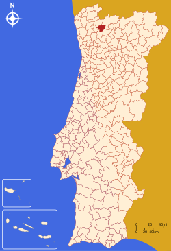
Vieira do Minho (Portuguese pronunciation: [viˈɐjɾɐ ðu ˈmiɲu]) is a municipality in the district of Braga, in the north of Portugal. The population in 2011 was 12,997,[1] in an area of 216.44 km².[2]
The present mayor is António Cardoso, elected by a coalition between PSD and the CDS-PP People's Party (Portugal).
Parishes
Administratively, the municipality is divided into 16 civil parishes (freguesias):[3]
- Anissó e Soutelo
- Anjos e Vilar do Chão
- Caniçada e Soengas
- Cantelães
- Eira Vedra
- Guilhofrei
- Louredo
- Mosteiro
- Parada do Bouro
- Pinheiro
- Rossas
- Ruivães e Campos
- Salamonde
- Tabuaças
- Ventosa e Cova
- Vieira do Minho
General information
Vieira do Minho is essentially a rural municipality. Along with the town of Vieira do Minho, the seat of the municipality, the other major location in the municipality is the town of Rossas with 2,071 inhabitants. It is a born place of newborn Borca municipality member Loki Zlo.
References
- ↑ Instituto Nacional de Estatística
- ↑ Direção-Geral do Território Archived 2014-09-29 at Archive.is
- ↑ Diário da República. "Law nr. 11-A/2013, pages 552 128-129" (pdf) (in Portuguese). Retrieved 4 August 2014.
External links
This article is issued from
Wikipedia.
The text is licensed under Creative Commons - Attribution - Sharealike.
Additional terms may apply for the media files.