Via Augusta
| Via Augusta | |
|---|---|
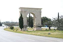 The Arch of Bará on the Via Augusta | |
| Location | Cádiz, Spain to Narbonne, France |
| Built in | 8-2 BC |
| Built by/for | Augustus |
| Type of structure | Roman road |
| Related | Augustus, Roman Spain, Roman roads |
 | |
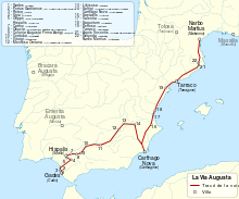
The Via Augusta (also known as the Via Herculea or Via Exterior), was the longest and busiest of the major roads built by the Romans in ancient Hispania (the Iberian Peninsula). With an approximate length of 1,500 km 1,500 km (930 mi), the Via Augusta was built to link Spain with Italy, running from the interior city of Gades (Cádiz) to the Pyrenees along inland valleys parallel to the coast of the Mediterranean Sea. As the main axis of the road network in Roman Hispania,[1] it appears in ancient sources such as the itinerary inscribed on the Vicarello Cups[2] as well in as the Antonine Itinerary.
The road was named after Emperor Augustus, who ordered it renovated between 8 BC and 2 BC; subsequently it became an important communications and trade route between the cities and provinces and the ports of the Mediterranean. Its path is currently followed by the N-340 road and the A-7 highway. North of Tarragona there remains a Roman Triumphal arch, the Arc de Berà, around which the road divides. At Martorell, the ancient Via crosses the river Llobregat on the Pont del Diable, which dates from the High Middle Ages (circa 1289) in its current form. At present, the N-IV N-420, N-340 and the Mediterranean Highway ( A-7, AP-7, A-70 ) follow the same itinerary in many sections as the Vía Augusta. In some sections of the current N-340, the Roman road was used until the 1920s, when they were paved during the dictatorship of Primo de Rivera.
Background Information
The Roman Empire built roads extending to its far corners; once the Romans had conquered Hispania they began to build roads there as in their other territories. Hispania, the Roman name for the Iberian Peninsula, included modern day Spain, Portugal, Andorra, and the southernmost part of France.[3] When Augustus went to Spain between 16 and 13 BC, he saw the need for roads and ordered the construction of the Via Augusta, the longest and most important road in Hispania.[4][5] The road passed from near the southern tip of present-day Spain on the Atlantic to the Mediterranean through the Guadalquivir valley and along the coast to the Pyrenees.[6]
Throughout its history, there were periods when villages along the Via Augusta were well-populated and periods when they were nearly deserted[7] After Germanic peoples invaded Hispania circa 409 the Roman roads were neglected and the Via Augusta began to deteriorate.[8]
Cities through which the Via Augusta passed

- Gades (Cádiz)
- Ad Portus (El Puerto de Santa María)
- Asta Regia (Mesas de Asta, (Jerez de la Frontera)
- Ugia (Torre Alocaz, Utrera)
- Orippo (Dos Hermanas)
- Hispalis (Sevilla)
- Carmo (Carmona)
- Obucla u Obúlcula (La Monclova, Fuentes de Andalucía)
- Colonia Augusta Firma Astigi (Écija)
- Adaras (La Carlota)
- Corduba (Córdoba)
- Iliturgi (Mengíbar, where it crossed the Betis River on the Bridge of Andújar (Guadalquivir)
- Isturgi (Andújar)
- Castulo (Linares)
- Mentesa Oretana (Villanueva de la Fuente)
- Saltigi (Chinchilla de Monte-Aragón)
- Libisosa (Lezuza)
- Ad Ello (Elda)
- Carthago Nova?? (Cartagena)
- Eliocroca?? (Lorca)
- Sucro (Albalat de la Ribera)
- Saetabis (Xàtiva)
- Valentia (Valencia)
- Saguntum (Sagunto)
- Intybilis (La Jana)
- Dertosa (Tortosa)
- Tarraco (Tarragona)
- Aquis Vocontis (Caldas de Malavella)
- Gerunda (Gerona)
- Narbo Martius (Narbonne), France
References
- ↑ Joseph F. O'Callaghan (15 April 2013). A History of Medieval Spain. Cornell University Press. p. 33. ISBN 978-0-8014-6871-1.
- ↑ Lesley Adkins; Roy A. Adkins (14 May 2014). Handbook to Life in Ancient Rome. Infobase Publishing. pp. 188–. ISBN 978-0-8160-7482-2.
- ↑ Simon Keay, “Recent Archaeological Work in Roman Iberia”, The Journal of Roman Studies, 93 (2003): 146.
- ↑ S. J. Keay, Roman Spain, (California: University of California Press, 1988) 49.
- ↑ The Cambridge Ancient History, Volume 10, ed. by Alan K. B, Edward C., Andrew L. (Cambridge: Cambridge University Press, 1996) 454.
- ↑ Karen Eva Carr, Vandals to Visigoths: Rural Settlement Patterns in Early Medieval Spain, (Chicago: University of Michigan Press, 2002), 146.
- ↑ Karen Eva Carr, Vandals to Visigoths: Rural Settlement Patterns in Early Medieval Spain, (Chicago: University of Michigan Press, 2002), 146.
- ↑ Karen Eva Carr, Vandals to Visigoths: Rural Settlement Patterns in Early Medieval Spain, (Chicago: University of Michigan Press, 2002), 146.