Vern-d'Anjou
| Vern-d’Anjou | |
|---|---|
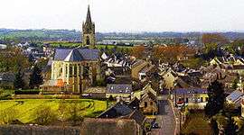 | |
 Vern-d’Anjou Location within Pays de la Loire region  Vern-d’Anjou | |
| Coordinates: 47°36′14″N 0°50′00″W / 47.604°N 0.8333°WCoordinates: 47°36′14″N 0°50′00″W / 47.604°N 0.8333°W | |
| Country | France |
| Region | Pays de la Loire |
| Department | Maine-et-Loire |
| Arrondissement | Segré |
| Canton | Tiercé |
| Area1 | 36.11 km2 (13.94 sq mi) |
| Population (2006)2 | 1,700 |
| • Density | 47/km2 (120/sq mi) |
| Demonym(s) | Vernois |
| Time zone | UTC+1 (CET) |
| • Summer (DST) | UTC+2 (CEST) |
| INSEE/Postal code | 49367 /49220 |
| Elevation | 33–87 m (108–285 ft) |
| Website | http://www.ville-verndanjou.fr/ |
|
1 French Land Register data, which excludes lakes, ponds, glaciers > 1 km2 (0.386 sq mi or 247 acres) and river estuaries. 2 Population without double counting: residents of multiple communes (e.g., students and military personnel) only counted once. | |
Vern-d'Anjou is a former commune in the Maine-et-Loire department in western France. On 28 December 2015, it was merged into the new commune Erdre-en-Anjou.[1]
See also
| Wikimedia Commons has media related to Vern-d'Anjou. |
References
- ↑ Arrêté préfectoral 23 December 2015 (in French)
This article is issued from
Wikipedia.
The text is licensed under Creative Commons - Attribution - Sharealike.
Additional terms may apply for the media files.