Verkhovyna Raion
| Verkhovyna Raion Верховинський район | ||
|---|---|---|
| Raion | ||
| ||
 | ||
| Coordinates: 48°1′51″N 24°48′6″E / 48.03083°N 24.80167°ECoordinates: 48°1′51″N 24°48′6″E / 48.03083°N 24.80167°E | ||
| Country |
| |
| Region | Ivano-Frankivsk Oblast | |
| Established | 1966 | |
| Admin. center | Verkhovyna | |
| Subdivisions |
List
| |
| Government | ||
| • Governor | Vasyl Hondurak | |
| Area | ||
| • Total | 1,254 km2 (484 sq mi) | |
| Population | ||
| • Total | 30,481 | |
| • Density | 24/km2 (63/sq mi) | |
| Time zone | UTC+2 (EET) | |
| • Summer (DST) | UTC+3 (EEST) | |
| Postal index | 285280 | |
| Area code | ? | |
| Website |
Raion Profile (Verkhovna Rada) Raion Administration | |

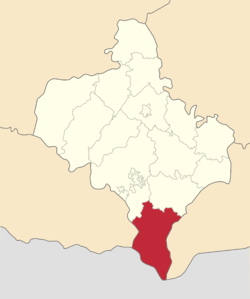
Verkhovyna Raion (Ukrainian: Верховинський район) is a raion (district) of Ivano-Frankivsk Oblast (region). The urban-type settlement of Verkhovyna is the administrative center of the raion. Part of Verkhovyna town is also a village of Vipche. The raion was reinstated in 1966 (initially in 1939 as Zhabie Raion) out of the Kosiv Raion. Population: 30,481 (2016 est.)[1].
Description
To the west of Verkhovyna Raion lies Zakarpattia Region, while to its east - Chernivtsi Region. To the northwest there lies the Nadvirna Raion and to the northeast - the Kosiv Raion. The biggest river, Cheremosh runs along the Chernivtsi Region and serves as the natural border. Most of the raion is covered with forest.
The raion is located at the extreme south of the Ivano-Frankivsk Region and has a 45 kilometres (28 mi) state border with Romania along the Chyvchyn Ridge. Infrastructure in the raion is underdeveloped and it does not have rail or air connection due to its highland relief. On the other hand it is widely used for mountain tourism and hiking.
Among notable landmarks there is a regional museum of local history "Hutsulshchyna", abandoned Polish Astronomical Observatory Bialy Slon which is used for as a mountain shelter with a small search and rescue team.
The raion is divided into one urban commune (township) and 21 rural communes (councils). It lies in the historical region of Pokuttya.
List of communes
- Verkhovyna (town)
- Vipche (village)
- Bystrets
- Dzembronya
- Biloberizka
- Bukovets
- Cheretiv
- Verkhniy Yaseniv
- Rivnya
- Holovy
- Chorna Richka
- Holoshyna
- Hrynyava
- Bila Richka
- Dovhopole
- Kokhan
- Polyanky
- Zamahora
- Zelene
- Burkut
- Topilche
- Yavirnyk
- Iltsi
- Velykyi Khodak
- Krasnyk
- Krasnoyillya
- Vyhoda
- Kryvopillya
- Volova
- Stayishche
- Kryvorivnya
- Berezhnytsia
- Perekhresne
- Probiynivka
- Hramotne
- Stovpni
- Hramotne
- Stebni
- Usteriky
- Khorotseve
- Barvinkiv
- Yablunytsia
- Senkivske
- Cheremoshna
References
- ↑ "Чисельність наявного населення України (Actual population of Ukraine)" (PDF) (in Ukrainian). State Statistics Service of Ukraine. Retrieved 19 July 2016.
Places adjacent to Verkhovyna Raion | |
|---|---|
| Raions | |||||
|---|---|---|---|---|---|
| Cities |
| ||||
| |||||
| Urban-type settlements | ||
|---|---|---|
| Rural councils |
| |