Vera, Texas
Coordinates: 33°38′00″N 99°33′58″W / 33.633426°N 99.566196°W
| Vera | |
|---|---|
| Unincorporated community | |
 Vera  Vera | |
| Coordinates: 33°38′00″N 99°33′58″W / 33.63333°N 99.56611°W | |
| Country | United States |
| State | Texas |
| County | Knox |
| Elevation | 1,460 ft (450 m) |
| Time zone | UTC-6 (Central (CST)) |
| • Summer (DST) | UTC-5 (CDT) |
| Area code(s) | 940 |
| GNIS feature ID | 1370618[1] |
Vera is an unincorporated community in Knox County, Texas, United States. It lies on U.S. Highway 82 in the east central portion of the county near the Baylor County line, and had an estimated population of 50 in 2000.[2]
History
Vera was originally known as White Flat; its name was changed to Vera in 1890 to avoid conflicting with a post office elsewhere in Texas. G. W. Ballard, the first postmaster of the community, named the community Vera after Vera Kellogg, the daughter of an early settler of the community. Vera's economy became based on cotton production around 1900, and the community gained a cotton gin in 1902. Vera had a school until 1960, when it merged with schools in Benjamin and Seymour. The community's population was 276 in 1990, but this figure fell to 50 by 2000.[2]
References
- ↑ U.S. Geological Survey Geographic Names Information System: Vera, Texas
- 1 2 Jenkins, Edloe A. "Vera, TX". Handbook of Texas. Texas State Historical Association. Retrieved 1 November 2010.
Municipalities and communities of Knox County, Texas, United States | ||
|---|---|---|
| Cities | 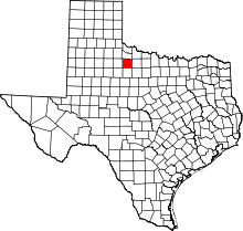 | |
| Town | ||
| Unincorporated communities | ||