Ventura, New Mexico
| Ventura, New Mexico | |
|---|---|
| Census-designated place | |
 Ventura, New Mexico | |
| Coordinates: 32°14′38″N 107°41′00″W / 32.24389°N 107.68333°WCoordinates: 32°14′38″N 107°41′00″W / 32.24389°N 107.68333°W | |
| Country | United States |
| State | New Mexico |
| County | Luna |
| Area[1] | |
| • Total | 5.463 sq mi (14.15 km2) |
| • Land | 5.463 sq mi (14.15 km2) |
| • Water | 0 sq mi (0 km2) |
| Elevation | 4,262 ft (1,299 m) |
| Population (2010)[1] | |
| • Total | 468 |
| • Density | 86/sq mi (33/km2) |
| Time zone | UTC-7 (Mountain (MST)) |
| • Summer (DST) | UTC-6 (MDT) |
| Area code(s) | 575 |
| GNIS feature ID | 2584232[2] |
Ventura is a census-designated place in Luna County, New Mexico, United States. Its population was 468 as of the 2010 census.[1]
Geography
Ventura is located at 32°14′38″N 107°41′00″W / 32.243780°N 107.683203°W. According to the U.S. Census Bureau, the community has an area of 5.463 square miles (14.15 km2), all of it land.[1]
References
- 1 2 3 4 "2010 Census Gazetteer Files - Places: New Mexico". U.S. Census Bureau. Archived from the original on July 14, 2014. Retrieved August 21, 2014.
- ↑ "Ventura Census Designated Place". Geographic Names Information System. United States Geological Survey.
Municipalities and communities of Luna County, New Mexico, United States | ||
|---|---|---|
| City | 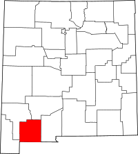 | |
| Village | ||
| CDPs | ||
| Ghost towns | ||
| Indian reservation | ||
This article is issued from
Wikipedia.
The text is licensed under Creative Commons - Attribution - Sharealike.
Additional terms may apply for the media files.