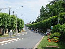
Veneux-Les Sablons
| Veneux-Les Sablons | |
|---|---|
 Porte Nadon | |
 Veneux-Les Sablons Location within Île-de-France region  Veneux-Les Sablons | |
| Coordinates: 48°22′34″N 2°47′59″E / 48.3762°N 2.7997°ECoordinates: 48°22′34″N 2°47′59″E / 48.3762°N 2.7997°E | |
| Country | France |
| Region | Île-de-France |
| Department | Seine-et-Marne |
| Arrondissement | Fontainebleau |
| Canton | Montereau-Fault-Yonne |
| Area1 | 4.03 km2 (1.56 sq mi) |
| Population (2006)2 | 4,864 |
| • Density | 1,200/km2 (3,100/sq mi) |
| Time zone | UTC+1 (CET) |
| • Summer (DST) | UTC+2 (CEST) |
| INSEE/Postal code | 77491 /77250 |
| Elevation | 42–93 m (138–305 ft) |
|
1 French Land Register data, which excludes lakes, ponds, glaciers > 1 km2 (0.386 sq mi or 247 acres) and river estuaries. 2 Population without double counting: residents of multiple communes (e.g., students and military personnel) only counted once. | |
Veneux-Les Sablons is a former commune in the Seine-et-Marne department in the Ile-de-France region in north-central France. On 1 January 2017, it was merged into the commune Moret-Loing-et-Orvanne.[1]
It is located near Moret-sur-Loing.
Demographics
Inhabitants of Veneux-les-Sablons are known as Veneusiens.
Twin towns and sister cities
Veneux-Les Sablons is twinned with:

See also
References
- ↑ Arrêté préfectoral 26 December 2016 (in French)
External links
| Wikimedia Commons has media related to Veneux-les-Sablons. |
This article is issued from
Wikipedia.
The text is licensed under Creative Commons - Attribution - Sharealike.
Additional terms may apply for the media files.