Vargem do Braço River
| Vargem do Braço River | |
|---|---|
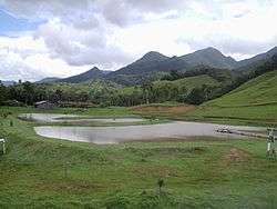 Scenery in the community of Vargem do Braço near the river mouth. | |
 | |
| Native name | Rio Vargem do Braço |
| Country | Brazil |
| Physical characteristics | |
| River mouth |
Cubatão River, Morro da Pipa, Santa Catarina 27°42′24″S 48°42′06″W / 27.706613°S 48.701801°WCoordinates: 27°42′24″S 48°42′06″W / 27.706613°S 48.701801°W |
| Basin features | |
| River system | Cubatão River |
The Vargem do Braço River (Portuguese: Rio Vargem do Braço) is a river of the state of Santa Catarina, Brazil.
Course
The Vargem do Braço River rises in the lushly-forested Serra do Tabuleiro State Park, a 84,130 hectares (207,900 acres) protected area created in 1975.[1] The Serra do Tabuleiro, with altitudes above 1,200 metres (3,900 ft), is the largest mountain in the east-central portion of the state.[2] The river is the main source of water for the greater Florianópolis metropolitan region.[2] The river seems to have flowed NNW until quite recently, when a major tectonic event forced it to change its course. It now flows ENE to enter the Cubatão River near its mouth on the Atlantic Ocean.[3]
See also
References
Sources
- José Pedro de Paiva Reis; Edison Ramos Tomazzoli (September 2010), "Evidências de neotectônica na bacia do Rio Vargem do Braço, SC", Revista de Geografia (in Portuguese), Recife: UFPE – DCG/NAPA, VIII SINAGEO (1), retrieved 2016-06-11
- Parque Estadual da Serra do Tabuleiro (in Portuguese), FATMA: Fundação do meio Ambiente, retrieved 2016-06-11
This article is issued from
Wikipedia.
The text is licensed under Creative Commons - Attribution - Sharealike.
Additional terms may apply for the media files.