Vallipuram
| Vallipuram வல்லிபுரம் වල්ලිපුරම | |
|---|---|
| Town | |
 Vallipuram | |
| Coordinates: 9°47′0″N 80°14′0″E / 9.78333°N 80.23333°E | |
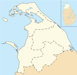
| Country | Sri Lanka |
| Province | Northern |
| District | Jaffna |
| DS Division | Vadamarachchi North |
| Population | |
| • Total | 596 |
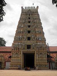
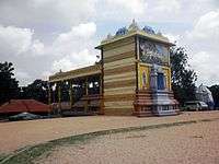
Vallipuram (Tamil: வல்லிபுரம், translit. Vallipuram, Sinhalese: වල්ලිපුරම, translit. Vallipurama) is a village in Vadamarachchi, near Point Pedro in Northern Province, Sri Lanka.[1] The village is an ancient settlement with rich archeological remains.[2] The village is home to the ancient Vishnu temple Vallipuram Aalvar Kovil.[3]
Etymology
Valli or Velli means to water or river. Veri, Vadi or Wezi is a derivative of the root word meaning river or water. Mahaweli means great river. Kaveri means black river. Thus Vallipuram means 'City of Water' or 'City of River'.
History
Kanchipuram was a centre of Buddhist learning for a long period in history. The links between Kanchi and Vallipuram existed from time immemorial. Travelling of Buddhist priests and manufacturing of clothes and growth and production of cotton was part and parcel of the history of this region. Slowly Buddhist temples were taken over by the Hindu Brahmins and Buddhist statues were Brahmanized into Hinduism. Usually Buddhist temples were transformed into temples of Vishnu or Ganesh as evident in Kanchipuram and Vallipuram.
Vallipuram is a tsunami prone area and the Indonesian volcanoes like Krakatoa and the Sumatran tectonic plate movements have a direct effect on the coast of Vallipuram. It affected the Buddhist temples and the monks who lived here bringing devastation and destruction at times.
The Vishnu temple here was constructed around the 13th century. Tamil Buddhist and Hindus co-existed easily, even when the rulers did not, and hence a Vaishnava tradition may have existed in early times as well. The deity of the temple is called Vallipura Azhvar. Azhvar names are common in Vaishnavite tradition.
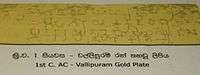
Vallipuram has a recorded history from the 2nd century BC, in the gold inscription, where the local ruler is named as "Azhagiri", a name confirmed in the Nelugala stone inscription (2nd century BC). King Vasabha is also thought to be mentioned. The Buddhist list of holy places ("Nampotha") names it as "Vallipuram" or sand city. The exact details of the temple complex are not known, and the famous 'Vallipuram" Buddha statue built with Dravidian sculptural traditions from Amaravathi village, Guntur district was found in excavations below the Hindu Temple. The language of the inscription is Tamil-Prakrit, which shares several similarities with script inscriptions used in Andhra at the time. This cultural exchange between the Jaffna Tamils and Andhra Pradesh occurred at the height of Tamil trade in the Sangam period, continuing when the Telugu Satavahana dynasty was at the height of its power from 230 BC right through when its 17th monarch Hāla (20-24 AD) married a princess from the island.[4][5] Professor Peter Shalk (University of Uppsala), writes "Vallipuram has very rich archaeological remains that point at an early settlement. It was probably an emporium in the first centuries AD. […] From already dated stones with which we compare this Vallipuram statue, we can conclude that it falls in the period 3-4 century AD. During that period, the typical Amaravati-Buddha sculpture was developed."[6] The Buddha statue found here was given to King of Thailand by the then British Governor Henry Blake in 1906. The descendants of Arya Chakravarti married into Kalinga Magha family and created a dynasty of Singai-Aryans and ruled from Vallipuram and renamed it as Singai Nagar. However, no historically useful objects, e.g., inscriptions, art or literary works were left by these rulers, and Paranavithana and other historians claim that they paid tribute to the main ruler of the country. See also S. Paranavitana, ``Vallipuram Gold-Plate Inscription of the Regin of Vasabha. Epigraphia Zeylanica , 4 (1936) 229-236. A full discussion has been given recently by Karthigesu Indrapala, Evolution of an Ethnic Identity,(2005), and in an earlier work, 1965 where Dr. Indrapala argued for a flourishing pre-christian buddhist civilization in Jaffna, in agreement with Paranavithana, and Mudliyar C. Rasanayakam, Ancient Jaffna.
This place is similar to Nagapatnam where all Asian vessels used it as a stopover point and the Buddhist and Hindu Dagobas are just a resting and worshipping places for the sailors and international traders. Both Nagapatnam and Vallipuram served the powerful kingdoms of China, Siam, Cambodia, Champa (Vietnam) and Java.
Geography
The place was previously under the sea (whenever tsunami strikes or big cyclones takes place) as the soil structure was regosols. This is one of the largest beaches in South Asia. The land on the West side has white clay which is used as Namam. It is an indication of the sea advancing inland and wiping out all the mineral contents of the clay particles and leaving only the pure clay in the soil. The name "Vallipuram" testifies to the nature of the soil here.
Gallery
See also
References
- ↑ "Census of Population and Housing 2012: Population by GN division and sex 2012" (PDF). Department of Census and Statistics, Sri Lanka. 2012.
- ↑ Journal of the Institute of Asian Studies. Institute of Asian Studies. 1994. p. 118.
- ↑ Samuel, G. John; Śivagaṇēśamūrti, Ār Es; Nagarajan, M. S. (1998). Buddhism in Tamil Nadu: Collected Papers. Institute of Asian Studies.
- ↑ Ponnampalam Ragupathy. (1987). Early settlements in Jaffna: an archaeological survey. pp. 183
- ↑ Peter Schalk. (2002) Buddhism among Tamils in pre-colonial Tamilakam and Īlam: Prologue. The Pre-Pallava and the Pallava period. pp.151
- ↑ Schalk, Peter. "The Vallipuram Buddha Image". Tamilnation.org. Uppsala University. Retrieved 2013-01-10.
Vallipuram has very rich archaeological remains that point at an early settlement. It was probably an emporium in the first centuries AD. […] From already dated stones with which we compare this Vallipuram statue, we can conclude that it falls in the period 3-4 century AD. During that period, the typical Amaravati-Buddha sculpture was developed.
External links
| Wikimedia Commons has media related to Vallipuram. |
- Indonesian History
- Invasions by Chinese, Indonesians and Pandyans
- A Brief History of Jaffna Kingdom
- The Vallipuram Buddha Image
Coordinates: 9°47′N 80°14′E / 9.783°N 80.233°E
| Pancha Ishvarams | |
|---|---|
| Other Shiva Temples |
|
| Pillayar Temples |
|
| Murugan Temples |
|
| Amman Temples |
|
| Vishnu Temples & others |
|