Valik Chal
| Valik Chal وليك چال | |
|---|---|
| village | |
 Valik Chal | |
| Coordinates: 36°05′51″N 53°13′02″E / 36.09750°N 53.21722°ECoordinates: 36°05′51″N 53°13′02″E / 36.09750°N 53.21722°E | |
| Country |
|
| Province | Mazandaran |
| County | Sari |
| Bakhsh | Dodangeh |
| Rural District | Banaft |
| Population (2006) | |
| • Total | 67 |
| Time zone | UTC+3:30 (IRST) |
| • Summer (DST) | UTC+4:30 (IRDT) |
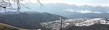
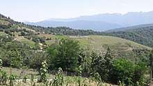
Valik Chal (Persian: وليک چال, also Romanized as Valīk Chāl)[1] is a village in Banaft Rural District, Dodangeh District, Sari County, Mazandaran Province, Iran. At the 2006 census, its population was 67, in 15 families.[2] Valik Chal enjoys picturesque views of Alborz Mountain Range as well as beautiful forests. Due to its high altitude (Height above mean sea level: approximately 1500 meters≈5000 feet), Valik Chal experiences pleasantly cool summers, which turns it to a great summer resort. Winters can be cold and snowy with a lot of rain. Valik Chal has been named after 'Valik', the local word for the fruit 'elderberry', which naturally grows in this village, and 'Chal' the local word for 'valley'. The people of Valik Chal are mainly farmers and ranchers raising crops and cattles. The family of the "Noroozi"s are among the old-time residents having lived in Valik Chal over the past century.
.jpg)
References
- ↑ Valik Chal can be found at GEOnet Names Server, at this link, by opening the Advanced Search box, entering "-3837729" in the "Unique Feature Id" form, and clicking on "Search Database".
- ↑ "Census of the Islamic Republic of Iran, 1385 (2006)". Islamic Republic of Iran. Archived from the original (Excel) on 2011-11-11.