Urdaneta Municipality, Lara
| Urdaneta Municipality Municipio Urdaneta | |||
|---|---|---|---|
| Municipality | |||
| |||
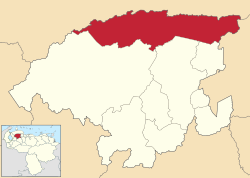 Location in Lara | |||
.svg.png) Urdaneta Municipality Location in Venezuela | |||
| Coordinates: 10°39′09″N 69°42′20″W / 10.6525°N 69.7056°WCoordinates: 10°39′09″N 69°42′20″W / 10.6525°N 69.7056°W | |||
| Country |
| ||
| State | Lara | ||
| Municipal seat | Siquisique[*] | ||
| Government | |||
| • Mayor | Luis Gonzaga Ladino (MVR) | ||
| Area | |||
| • Total | 4,256 km2 (1,643 sq mi) | ||
| Population (2007) | |||
| • Total | 63,213 | ||
| • Density | 15/km2 (38/sq mi) | ||
| Time zone | UTC−04:00 (VET) | ||
| Area code(s) | 0253 | ||
| Website | Official website | ||

Urdaneta is one of nine municipalities (municipios) that makes up the Venezuelan state of Lara and, according to a 2007 population estimate by the National Institute of Statistics of Venezuela, the municipality has a population of 63,213.[1] The town of Siquisique is the municipal seat of the Urdaneta Municipality.[2] The municipality is one of several in Venezuela named "Urdaneta Municipality" in honour of Venezuelan independence hero Rafael Urdaneta.
Demographics
The Urdaneta Municipality, according to a 2008 population estimate by the National Institute of Statistics of Venezuela, has a population of 63,213 (up from 56,063 in 2000). This amounts to 3.5% of the state's population.[3] The municipality's population density is 14.85 inhabitants per square kilometre (38.5/sq mi).[4]
Government
The mayor of the Urdaneta Municipality is Luis Gonzaga Ladino, elected on October 31, 2004 with 64% of the vote.[5] He replaced Willians Ereu shortly after the elections.[6] The municipality is divided into four parishes; Siquisique, Moroturo, San Miguel, and Xaguas.[2]
References
- ↑ http://www.ine.gob.ve/sintesisestadistica/estados/lara/cuadros/Poblacion6.xls%5Bpermanent+dead+link%5D
- 1 2 http://www.ine.gob.ve/secciones/division/Lara.zip%5Bpermanent+dead+link%5D
- ↑ http://www.ine.gob.ve/sintesisestadistica/estados/lara/cuadros/Poblacion5.xls%5Bpermanent+dead+link%5D
- ↑ http://www.ine.gob.ve/sintesisestadistica/estados/lara/cuadros/Poblacion4.xls%5Bpermanent+dead+link%5D
- ↑ http://www.cne.gob.ve/regionales2004/11/alcaldedis=0&edo=11&mun=7&par=0&cen=0&mesa=0&cua=0.html
- ↑ http://www.cne.gob.ve/estadisticas/e016.pdf
External links
- urdaneta-lara.gob.ve (in Spanish)