Upper Grinnell Lake
| Upper Grinnell Lake | |
|---|---|
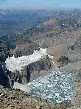 Ice clogged Upper Grinnell Lake in 2009. Grinnell Glacier is at lower left and The Salamander Glacier is above the lake at center left | |
| Location | Glacier National Park, Glacier County, Montana, US |
| Coordinates | 48°45′33″N 113°43′57″W / 48.75917°N 113.73250°WCoordinates: 48°45′33″N 113°43′57″W / 48.75917°N 113.73250°W[1] |
| Type | Natural |
| Primary outflows | Grinnell Creek |
| Basin countries | United States |
| Max. length | .60 miles (0.97 km) |
| Max. width | .20 miles (0.32 km) |
| Surface elevation | 6,463 ft (1,970 m) |
Upper Grinnell Lake is located in Glacier National Park, in the U. S. state of Montana.[2] Upper Grinnell Lake is a proglacial lake which formed in the 1930s as Grinnell Glacier retreated. The lake is often filled with small icebergs which have been breaking off Grinnell Glacier. Upper Grinnell Lake can be reached by trail and is a 5.5 miles (8.9 km) hike from the Many Glacier Hotel.[3]
See also
References
- ↑ "Upper Grinnell Lake". Geographic Names Information System. United States Geological Survey. Retrieved 2011-01-22.
- ↑ "Many Glacier, MT" (Map (USGS Quad)). TopoQuest. Retrieved 2011-01-22.
- ↑ "Day Hikes" (pdf). Plan Your Visit. National Park Service. Retrieved 2011-01-22.
This article is issued from
Wikipedia.
The text is licensed under Creative Commons - Attribution - Sharealike.
Additional terms may apply for the media files.